Bottom currents in the Black Sea: why they are deadly. What currents are there in the Black Sea? Warm and cold currents of the Black Sea
In the Black Sea there is Main Black Sea Current(Rim Current) - it is directed counterclockwise along the entire perimeter of the sea, forming two noticeable rings (“Knipovich glasses”, named after one of the hydrologists who described these currents). The basis of this movement of water and its direction is the acceleration imparted to water by the rotation of the Earth - the Coriolis force. True, in such a relatively small water area as the Black Sea, the direction and strength of the wind are no less important. Therefore, the Rim Current is very variable, sometimes it becomes poorly distinguishable against the background of smaller-scale currents, and sometimes its jet speed reaches 100 cm/s.
 In the coastal waters of the Black Sea, eddies of opposite direction to the Rim Current are formed - anticyclonic gyres, they are especially pronounced along the Caucasian and Anatolian coasts.
Local coastal currents in the surface layer of water are usually determined by the wind; their direction can change even during the day.
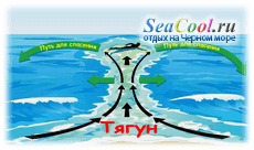
A special type of local coastal current - draft- forms on flat sandy shores during strong sea waves: the water flowing onto the shore does not retreat evenly, but along channels formed in the sandy bottom. Getting caught in such a current is dangerous - despite the efforts of the swimmer, he can be carried away from the shore; to get out, you need to swim not straight to the shore, but diagonally.
 Vertical currents: rise of water from depth - upwelling, most often occurs when driven away coastal surface waters from the shore by strong offshore winds; at the same time, water from the depths rises to replace the surface water driven into the sea. Since the water of the depths is colder than the surface waters heated by the sun, as a result of the surge, the water near the shore becomes colder. The surge of water off the Caucasian coast of the Black Sea, caused by a strong northeast wind (this wind is called bora here), can be so powerful that the sea level near the coast can drop by forty centimeters per day.
In the oceans, upwellings arise from the action of the Coriolis force (created by the movement of the Earth around its axis) on masses of water carried by currents in the meridional direction (from the poles to the equator) along the coasts of the continents: the Peruvian current and the Peruvian upwelling (the most powerful in the world) off the Pacific coast of the South America, the Benguela Current and the Benguela Upwelling off the eastern coast of South Africa .
Upwellings lift into the surface, illuminated layer of the ocean (or sea) water enriched with biogenic minerals (salt ions containing nitrogen, phosphorus, silicon), necessary for the growth and reproduction of phytoplankton microalgae - the basis of life in the sea. Therefore, upwelling areas are the most productive water areas - there is more plankton, fish, and everything that lives in the ocean.
The Black Sea is an inland sea of the Atlantic Ocean, washing the shores of Ukraine, Russia, Georgia, Romania, Bulgaria, and Turkey.
Area - 422 thousand km2, length between western and eastern points - about 1167 km, between northern and southern - 624 km. The largest peninsula is Crimean, the largest bays (off the coast of Ukraine) are Karkinitsky, Kalamitsky, Feodosiyskaya, Dzharylgachsky. The largest island off the coast of Ukraine is Zmeiny. The average depth is 1271 m, the maximum is 2245 m. The shores of the Black Sea are poorly dissected, most often mountainous, steep, but within the continental part of Ukraine they are flat.
Within Ukraine, large rivers flow into the Black Sea: Danube, Dniester, Southern Bug, Dnieper. Many resorts: Sochi, Gelendzhik, resorts of Crimea, Abkhazia, Bulgaria.
Most of the sea is located in the subtropical zone. Winter is warm and humid. The air temperature in January over the Black Sea is -1 ... + 8 ° C, the surface water temperature is + 8 ° ... 9 ° C, except in the northwestern and northeastern parts, where the sea freezes in severe winters. Summer is hot and dry. Air temperature +22 ... 25 ° C, surface water temperature H24 ... 26 ° C. Average precipitation increases from west to east from 200-600 to 2000 mm or more. Average salinity is 21.8%.
The waters of the Black Sea at depths of more than 50-100 m are saturated with hydrogen sulfide, which negatively affects its organic life.
In the Black Sea there are more than 300 species of algae and over 180 species of fish, living mainly in the upper layer (above the hydrogen sulfide zone). Anchovy, horse mackerel, mullet, flounder, mackerel, algae and invertebrates (mussels, shrimp, oysters) are of industrial importance. Every year the sea provides up to 300 thousand tons of biological resources. Industrial reserves of natural gas and oil have been explored. The mud of the Black Sea estuaries has medicinal value. The Black Sea has a number of bays convenient for ships.
The Black Sea extends from west to east for 1160 km, its greatest width is 580 km. The total water area exceeds 420 thousand km2. The sea fills a large tectonic depression. Its maximum depth is 2245 m. The largest bays are Dzharylgachsky, Karkinitsky, Kalamitsky, Feodosiyskaya, Sivash, Obitichna, Berdyansk. The rivers Danube, Dnieper, Dniester, and Southern Bug flow into the Black Sea. In areas between the rivers of the coast there are bodies of water connecting to the sea - estuaries. Of these, on the Black Sea coast there are the Dniester, Khadzhibey, Kuyalnitsky, Tiligulsky, Dnieper estuaries, and on the Azov coast - Utlyutsky, Molochny. The most peninsula of the Black Sea is the Crimean, which is connected to the mainland by the Perekop Isthmus. In the Sea of Azov, elongated areas of land - spits - attract attention. The largest among them is the Arabat Strelka Spit. In the Black Sea, the largest island is Dzharylgach.
The Kerch Strait connects the Black Sea with the Azov Sea. The depth of the strait is up to 4 m.
The climatic conditions of the Black Sea are characterized by subtropical features. Summer is dry and hot, winter is wet and warm. In winter, Mediterranean and Atlantic cyclones move over it, which are associated with rain and foggy weather. In summer, the Black Sea is under the influence of the Azores High, due to which cloudless weather prevails here, thunderstorms and tornadoes are rare occurrences.
Sea level fluctuations associated with high and low tides are insignificant, their amplitude is only 10 cm. Fluctuations under the influence of wind activity reach 1.5 m. Water temperature in summer is +24, + 26 ° C, and in winter it drops to +6, +7 ° C. From a depth of 150 m. The temperature became (8 ° C). In years with severe winters, the northwestern part of the Black Sea freezes.
The salinity of the upper layer of water in the Black Sea is 17-18%. With depth, salinity increases to 22.5%. Compare these indicators with the following: the average salinity of the World Ocean is 35% o, the Mediterranean Sea - up to 38, and the Red Sea - 40% o. Find out why the salinity of the Black Sea waters is much lower.
A characteristic feature of the natural conditions of the Black Sea is the existence in it of a permanent layer of hydrogen sulfide at depths below 100-120 m. This layer is inhabited by bacteria that use hydrogen sulfide. An important fact is that the hydrogen sulfide layer makes up 87% of the volume of the entire Black Sea. And only 13% of the Black Sea water contains oxygen; it is in this small layer that animals are found. Researchers note that hydrogen sulfide rises to the surface.
Every year, up to 300 thousand tons of biological resources are selected from the Black Sea. Construction sand, gravel, and flammable gas are also mined here; The search for oil fields on the shelf continues.
Permanent link to the file - http://site
+ additional material:
The main current observed in the Black Sea is called the "main Black Sea current". It spreads along all shores along the perimeter of the sea, directed counterclock-wise and folds into two vortex flows called rings. These rings, reminiscent of giant glasses and the name of the hydrologist who first noticed and described them, gave the name to this phenomenon - “Knipovich glasses”.
The basis for the direction of movement of the Black Sea current is the acceleration received by sea water due to the rotation of the planet. Physicists call this effect the “Coriolis force.” In addition to cosmic forces, the movement of surface water on the map of the Black Sea is also influenced by the force of the wind. This explains the variability of the main Black Sea current: sometimes it is barely noticeable against the background of other, smaller currents, and sometimes its speed reaches one meter per second.
In coastal areas Black Sea anticyclonic gyres are observed - vortex flows directed opposite to the main flow. They are most noticeable off the coast of the Caucasus and Anatolia. In these areas of the Black Sea, the direction of alongshore currents is usually determined by the direction of the prevailing wind and can change several times a day.
Vacationers on the Black Sea should know about the existence of such a type of local Black Sea currents as “ draft" Most often, this current forms during a storm near sandy, gently sloping shores. Water flowing onto the shore does not return evenly, but in streams along channels spontaneously formed in the sandy bottom. Getting caught in a current is dangerous: even an experienced swimmer, despite all his efforts, can be carried into the open sea far from the shore. To get out of the tug, you need to swim to the shore not directly perpendicular, but at an angle in order to reduce the counter resistance of the receding water.
A type of draft “in action” can be seen in the Black Sea ports. From time to time, ships moored to the pier begin movement along the shore, as if controlled by a huge natural force. Sometimes this movement is so powerful that the metal mooring ends cannot withstand the pressure, and the ships have no choice but to stop loading operations and lie down in a roadstead away from the shore.

The nature of the occurrence of “port” draft differs from the draft that occurs during a storm. It is caused by special waves, invisible to the naked eye, approaching the port gates. They are called long-period - the period of oscillations created by them is much longer than the periods of oscillation of ordinary waves.
Scientists in our country and abroad are studying the nature of this phenomenon. The result of their work is scientific and practical recommendations on the correct mooring of ships during “thrusts” and advice on designing safe ports capable of extinguishing the “evil” energy of long-period waves.
Map of Black Sea currents - cold and warm currents
What is a geographic map
A geographic map is an image of the Earth's surface with a plotted coordinate grid and symbols, the proportions of which directly depend on the scale. A geography map is a landmark by which you can identify the location of an array, object, or place of residence of a person. These are indispensable assistants for geologists, tourists, pilots and military personnel, whose professions are directly related to travel and trips over long distances.
Types of cards
Geographic maps can be roughly divided into 4 types:
- in terms of territory coverage and these are maps of continents and countries;
- by purpose and these are tourist, educational, road, navigation, scientific and reference, technical, tourist maps;
- content - thematic, general geographical, general political maps;
- by scale – small-scale, medium-scale and large-scale maps.
Each of the maps is dedicated to a particular topic, thematically reflecting islands, seas, vegetation, settlements, weather, soils, taking into account the coverage of the territory. A map can only represent countries, continents or individual states plotted on a certain scale. Taking into account how much a particular territory has been reduced, the scale of the map is 1x1000.1500, which means a decrease in distance by 20,000 times. Of course, it’s easy to guess that the larger the scale, the more detailed the map is drawn. And yet, individual parts of the earth's surface on the map are distorted, unlike a globe, which is capable of conveying the appearance of the surface without changes. The Earth is spherical and distortions occur, such as: area, angles, length of objects.
Black Sea Currents
The results of our studies of the currents of the Northern and Middle Caspian Sea differed significantly from the ideas that were most widespread. Therefore, we sought to compare them with published results from studies in other bodies of water. Gradually, we moved from studies of Caspian currents to studies of the nature of specific types of currents - wind, thermohaline, quasi-permanent circulations, long-wave, inertial, etc. in various reservoirs - in the Black Sea, in the Sea of Okhotsk, in lakes Ladoga, Huron, etc. ., in those reservoirs for which it is possible to find measurement results.
This approach significantly expands the amount of experimental data suitable for analysis. We can compare current parameters in different bodies of water. This will allow us to better understand the properties of the studied processes of formation and existence of flows. The main research methods were invented during studies of the currents of the Northern and Middle Caspian Sea.
Let us consider the results of instrumental observations of currents in various seas and large lakes.
2.1. Black Sea Currents
The area of the Black Sea is 423,488 km. The greatest width along the parallel is 42°21′ N. – 1148 km, along the meridian 31°12′ E – 615 km. Coastline length 4074 km.
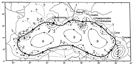
Rice. 2.1. Black Sea water circulation diagram. 1 – Annular cyclonic current (ACC) – average position of the rod; 2 – CCT meanders; 3 – coastal anticyclonic eddies (SAEs); 4 – cyclonic eddies (CV); 5 – Batumi anticyclonic vortex; 6 – Kaliar surfactant; 7 – Sevastopol surfactant; 8 – Kerch surfactant; 9 – quasi-stationary cyclonic gyres (Kosyan R.D. et al. 2003).
The general circulation of the Black Sea waters - the Main Black Sea Current (Rim Current) is characterized by cyclonic movement of waters (Fig. 2.1). Its main structural element is the Annular Cyclonic Current (RCC). Near the Caucasian coast, the CCT occupies a strip along the coast 50-60 km wide and carries its waters in a general direction to the northwest. The centerline of the flow can be traced at a distance of 20-35 km from the coast, where speeds reach 60-80 cm/s. This current penetrates to a depth of 150-200 m in the summer, 250-300 m in the winter, sometimes to a depth of 350-400 m. The current core experiences wave-like oscillations, deviates either to the right or to the left from its average position, i.e. This jet the current meanders. In Fig. 2.1. the most common idea of the structure of the Black Sea currents is presented.
The results of current measurements carried out over a period of 5 months in coastal waters in the northeastern part of the Black Sea are shown in Fig. 2.2.
In the figures we see that the currents cover the entire water column, the changes are synchronous at all horizons.
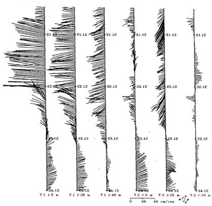
Rice. 2.2. Fragment of the time sequence of half-hour current vectors from December 20 to December 23, 1997. Point 1 – horizons of 5, 26 and 48 m; point 2 – horizons 5 and 26 m; point 3 – horizon 10 m (Kosyan R.D. et al. 2003).
These studies did not filter to identify long-period wave currents. The measurements lasted 5 months, i.e. It is possible to show about 5 periods of variability of long-period wave currents and their variability at different points, differences and common features as they move away from the coast. Instead, the authors provide explanations that are consistent with traditional views.
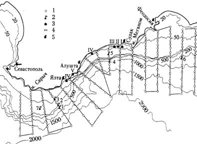
Rice. 2.3. Location of instruments off the southern coast of the Crimean Peninsula at points 1–5 (Ivanov V. A., Yankovsky A. E. 1993).

Rice. 2.4. Variability of current speed at measurement points 3 and 5 (Fig. 2.12) at a horizon of 50 m. High-frequency oscillations with a period of 18 hours. And less filtered using a Gaussian filter. (Ivanov V. A., Yankovsky A. E. 1993).
Measurements of currents in the coastal zone using autonomous buoy stations (ABS) were carried out off the southern coast of the Crimean Peninsula in the Black Sea at 6 points on 4 horizons from June to September 1991 (Fig. 2.3). (Ivanov V. A., Yankovsky A. E. 1993).
One of the main tasks is the study of waves captured by the shore. Long-wave currents with a period of 250-300 hours have been recorded. and amplitude up to 40 cm/s (Fig. 2.4). The phase propagated westward at a speed of 2 m/s. (Note that the value of the phase velocity is obtained from calculation, and not from the difference in the time of passage of the wave at two adjacent points).
Water circulation in the upper layer of the Black Sea is shown using drift data (Zhurbas V.M. et al. 2004). More than 61 drifters were launched in the Black Sea, which were carried by the current of large-scale circulation along the coast.

Rice. 2.5. Trajectory of drifter No. 16331 in the southwestern part of the Black Sea. The numbers on the trajectory are the day that has passed since the drifter was launched (Zhurbas V.M. et al. 2004).
The patterns of drifter advancement show the patterns of currents. The most common misconception about the nature of currents in the Black Sea: cyclonic circulation currents are jet meandering current. Meanders, breaking away from the main jet, form vortices. The authors demonstrate such a “vortex” in Fig. 2.5.
The following figure (2.6) shows the variability of the components of the speed of movement (current) of the drifter along the trajectory. The periodic variability of the current speed is clearly visible. The period of variability is from 2 to 7 days. The speed varies from - 40 cm/s. up to 50 cm/s, but the average speed (thick line) is close to zero. The drifter moves along a circular path. It reflects the movement of a water mass of a wave nature.
Bondarenko A.L. (2010) shows the path of one of the drifters in the Black Sea (Fig. 2.7), and the variability of the speed of the drifter’s movement along the trajectory (Fig. 2.8). Just as in the previous work, it is clear that currents of a wave nature are observed, and not a jet, meandering current. The path taken by the drifter during the initial period of its voyage attracts attention. The starting point (0) is in the center of the western part of the sea.

Rice. 2.6. Time series of drifter velocity components 16331. Ut is the longitudinal component of the velocity (+/- east/west, respectively), Vt is the latitudinal component [Zhurbas V.M. et al. 2004].
According to ideas (Fig. 2.1), this point is located outside the CCT. But we see that the drifter made a cyclonic path along a stretched almost ellipse, then moved southwest for 20 days. the direction where he got into the CCT and moved in it the entire further path. From this trajectory it is possible to calculate the flow velocity in different sections of the trajectory, and from (Fig. 2.8) the periodicity of the r.f. and n.ch. variability of this speed.
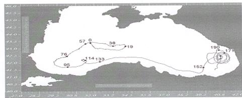
Rice. 2.7. Drifter's path in the Black Sea ( Bondarenko A.L., 2010).
The measurement examples discussed above show that the Main Black Sea Current, the Circular Cyclonic Current (ACC), is the resulting movement of long-period wave currents. The understanding of the geostrophic nature of the CCT currents and its meandering is erroneous. The period of variability of wave currents in the northern part is 260 hours. As we move along the coast, due to the unevenness of the coastline and bottom surface, the components of the current velocity across the coast become comparable with the components along the coast, the trajectories of drifters acquire a ring-shaped shape. The period of variability is greatly reduced.

Rice. 2.8. AND variability of the speed of movement of the drifter along the trajectory shown in Fig. 2.7.(Bondarenko A.L., 2010).