How inclement weather occurs. Front in the atmosphere. What is an atmospheric front? The passage of a warm front is accompanied by
It turned out that warm air is drawn into the cyclone not throughout its entire eastern (right) half, but in a fairly limited sector located in the southern and southeastern parts of the cyclone between two convergence lines. Cloudiness and precipitation are distributed unevenly in the cyclone. Covering rains fall mainly in front of the first (eastern) line of convergence of air flows, as well as in the center of the cyclone. Showers and thunderstorms are concentrated in a narrow band along the second (western) convergence line. These lines were subsequently called atmospheric fronts. Since in temperate latitudes Cyclones usually move from west to east; the eastern front of the cyclone first passes through the observation point, followed by warm air. This atmospheric front was called a warm front. In the vicinity of a warm atmospheric front, warm air actively advances onto the front line, moves almost perpendicular to it, and cold air is transported almost parallel to this line, i.e. slowly retreats from her. Consequently, the warm air mass catches up and overtakes the cold one. Then the western (cold) front of the cyclone approaches the observation point, as it passes the air temperature drops sharply. Near a cold atmospheric front, the dynamics are different: cold air catches up with warm air and rapidly displaces it upward.
The upward sliding covers thick layers of warm air over the entire frontal surface and an extensive system of high-stratus clouds with overlying precipitation arises. The warm front has an anticyclonic curvature and moves towards the cold air. On a weather map, a warm front is marked in red or with blackened semicircles directed in the direction of the front’s movement (Fig. 1). As the warm front line approaches, pressure begins to drop, clouds thicken, and heavy precipitation begins to fall. In winter, low stratus clouds usually appear when a front passes. The temperature and humidity are slowly increasing. As a front passes, temperatures and humidity typically rise quickly and winds pick up. After the front passes, the direction of the wind changes (the wind turns clockwise), its speed decreases, the pressure drop stops and its slight increase begins, the clouds dissipate, and precipitation stops. The field of pressure trends is presented as follows: in front of the warm front there is closed area a drop in pressure, behind the front - either an increase in pressure, or a relative increase (a drop, but less than in front of the front). Walkthrough warm front usually accompanied by a powerful nimbus layer covering the entire sky with heavy rain. The first sign of a warm front is cirrus clouds. Gradually they turn into a continuous white veil of cirrostratus clouds. IN upper layers Warm air is already moving into the atmosphere. The pressure drops. The closer the front line is to us, the denser the clouds become. The sun shines through as a dim spot. Then the clouds drop lower and the sun disappears completely. The wind intensifies and changes its direction clockwise (for example, at first it was easterly, then southeasterly and even southwest). Approximately 300-400 km before the front, the clouds thicken. Light continuous rain or snow begins. But the warm front has passed. The rain or snow has stopped, the clouds are dissipating, warming is coming - a warmer air mass has arrived. The warm front in a vertical section is shown in Fig. 2.

If the warm air retreats and the cold air spreads out after it, it means that a cold front is approaching. His arrival always causes a chill. But when moving, not all layers of air have the same speed. The lowest layer as a result of friction against earth's surface is delayed a little, and the taller ones are pulled forward. Thus, cold air falls on warm air in the form of a shaft. Warm air is quickly forced upward and powerful piles of cumulus and cumulonimbus clouds are created. The clouds of the cold front carry showers, thunderstorms, accompanied by strong gusty winds. They can reach very high altitudes, but in the horizontal direction they extend only 20...30 km. And since the cold front usually moves quickly, stormy weather does not last long - from 15...20 minutes. up to 2...3 hours. As a result of the interaction of cold air with the warm underlying surface, cumulus clouds with gaps are formed. Then comes complete clarity.
In the case of a cold front, the upward movement of warm air is limited to a narrower zone and is especially strong in front of the cold wedge, where warm air is displaced by cold air. The clouds here will be largely cumulonimbus with showers and thunderstorms (Fig. 3, Fig. 4). Cold front has a cyclonic curvature (convexity towards warm air) and moves towards warm air. On a weather map, a cold front is marked in blue or with blackened triangles directed in the direction the front is moving (Fig. 1). The flow in cold air has a component directed towards the front line, so cold air, moving forward, occupies the space where warm air was previously located, which increases its instability.
When crossing the line of a warm front, the wind, as in the case of a warm front, turns to the right, but the turn is more significant and sharp - from the southwestern, southern (in front of the front) to the western, northwestern (behind the front). At the same time, the wind speed increases. Atmosphere pressure before the front changes slowly. It may fall, but it can also rise. With the passage of a cold front, a rapid increase in pressure begins. Behind the cold front there is a closed isallobaric region of pressure growth, and the increase can reach 3-5 hPa/3h. A change in pressure in the direction of its growth (from a decrease to an increase, from a slow increase to a stronger one) indicates the passage of the surface front line.
Thunderstorms and squalls are common ahead of the front. After the front passes, the air temperature drops, often quickly and sharply – by 10 °C or more in 1-2 hours. The mass fraction of water vapor decreases simultaneously with the air temperature. Visibility typically improves as polar or arctic air moves in behind the cold front. In addition, the instability of the air mass prevents condensation near the Earth's surface.
The nature of the weather on a cold front varies markedly depending on the speed of the front's movement, the properties of warm air ahead of the front, and the nature of the upward movements of warm air above the cold wedge. Cold fronts of the 1st type are dominated by an orderly rise of warm air above a wedge of cold air. A type 1 cold front is a passive upward sliding surface. Slowly moving or slowing down their movement fronts belong to this type, mainly on the periphery of cyclonic regions in deep baric troughs. In this case, the clouds are located mainly behind the front line. There is still a difference from the cloudiness of a warm front. Due to friction, the surface of the cold front in the lower layers becomes steep. Therefore, just before the front line, instead of a calm and gentle upward sliding, a steeper (convective) rise of warm air is observed (Fig. 3). Due to this, powerful cumulus and cumulonimbus clouds sometimes appear in the front part of the cloud system, stretching for hundreds of kilometers along the front, with showers in summer, snowfall in winter, thunderstorms, hail and squalls. Over the overlying part of the frontal surface with a normal slope as a result of the upward sliding of warm air, the cloud system represents a uniform cover of stratus clouds. Rainfall ahead of the front after the passage of the front is replaced by more uniform blanket precipitation. Finally, cirrostratus and cirrus clouds appear. The vertical power of the system and the width of the cloud system and precipitation area will be almost 2 times less than in the case of a warm front. The upper boundary of the system is approximately at an altitude of 4-4.5 km. Stratus broken clouds may develop beneath the main cloud system, and frontal fogs may sometimes form. The duration of passage of a cold front of the 1st type through an observation point is 10 hours or more.

Fronts of the 2nd kind in the lower layer of the atmosphere are a passive ascending slip surface, and above them are an active downward sliding surface. Most fast-moving cold fronts in cyclones belong to this type. Here, the warm air of the lower layers is displaced upward by the cold shaft moving forward. The surface of the cold front in the lower layers is very steep, even forming a bulge in the form of a shaft (Fig. 4). The rapid movement of a wedge of cold air causes forced convection of displaced warm air into narrow space at the front part of the frontal surface. Here a powerful convective flow is created with the formation of cumulonimbus clouds, intensifying as a result of thermal convection. The harbingers of the front are altocumulus lentiform clouds, which spread in front of it at a distance of up to 200 km. The emerging cloud system has a small width (50-100 km) and does not represent individual convective clouds, but a continuous chain, or a cloud bank, which sometimes may not be continuous. In the warm half of the year, the upper boundary of cumulonimbus clouds extends to the height of the tropopause. On cold fronts of the 2nd type, intense thunderstorm activity, showers, sometimes with hail, and squally winds are observed. There is strong turbulence and icing in the clouds. Zone width hazardous phenomena weather distance is several tens of kilometers. In the cold half of the year, the tops of cumulonimbus clouds reach 4 km. The width of the snowfall zone is 50 km. Associated with this cloudiness heavy snowfalls, snowstorms with visibility less than 1000 m, a sharp increase in wind speed, bumpiness.

When cold fronts of the 2nd type pass through an observation point, cirrus clouds first appear (3-4 hours before the front line passes near the Earth), which are quickly replaced by altostratus, sometimes lenticular, which are quickly replaced by a huge cloud with showers, thunderstorms, hail, and squalls. The duration of movement of a cloud system with showers and thunderstorms usually does not exceed 1-2 hours. After the cold front passes, the rainfall stops. A feature of cold fronts of both the first and second types are prefrontal squalls. Since in the front part of the cold wedge, due to friction, a steep slope of the frontal surface is created, part of the cold air appears above the warm one. Next, the cold air masses “collapse” down in the front part of the advancing cold shaft. The collapse of cold air leads to the displacement of warm air upward and to the appearance of a vortex with a horizontal axis along the front. Squalls on land are especially intense in the summer, when there is a large temperature difference between warm and cold air on both sides of the front and when warm air is unstable. Under these conditions, the passage of a cold front is accompanied by destructive wind speeds. The wind speed often exceeds 20-30 m/s, the duration of the phenomenon is usually several minutes, and gusts are sometimes observed.
Occlusion fronts
Due to downward movements in the cold air at the rear of the cyclone, the cold front moves faster than the warm front and over time catches up with it. At the stage of filling the cyclone, complex fronts arise - occlusion fronts, which are formed when cold and warm atmospheric fronts close.
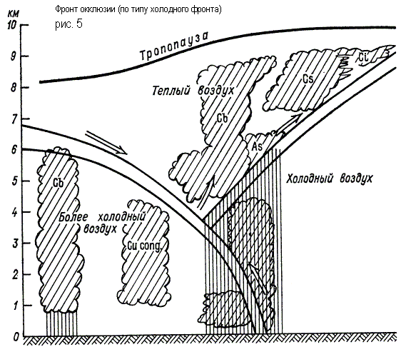
In the occlusion front system, three air masses interact, of which the warm one no longer comes into contact with the Earth’s surface. The process of displacing warm air into the upper layers is called occlusion. In this case, the rear wedge of cold air of the cyclone closes with the front wedge of cold air. Warm air in the form of a funnel gradually rises upward, and its place is taken by cold air coming from the sides (Fig. 5). The interface that occurs when cold and warm fronts meet is called the occlusion front surface.
In the case of an occluded cold front, precipitation can occur on both sides of the lower front, and the transition from blanket precipitation to showers, if it occurs, occurs not ahead of the lower front, but in close proximity to it. In the case of a warm occlusion front, the vortex of warm air is displaced by warmer air flowing onto a wedge of colder air. The rear wedge of less cold air overtakes the front wedge of colder air, and the cold front, having separated from the Earth's surface, rises along the surface of the warm front.
A weak upward sliding of the rear air along the front along the occlusion surface can lead to the formation of St-Sc clouds along it, not reaching the level of the ice cores. These will produce some drizzle ahead of the lower warm front.
Weather cold VM
Warm weather VM
Warm VM, moving to a cold area, becomes stable (cooling from the cold underlying surface). The air temperature, falling, can reach the level of condensation with the formation of haze, fog, low stratus clouds with precipitation in the form of drizzle or small snowflakes.
Conditions for flying in a warm aircraft in winter:
Weak and moderate icing in clouds at subzero temperatures;
Cloudless sky, good visibility at H = 500-1000 m;
Weak bumpiness at H = 500-1000 m.
In the warm season, conditions for flights are favorable, with the exception of areas with isolated centers of thunderstorms.
When moving to a warmer area, a cold VM heats up from below and becomes unstable. Powerful upward air movements contribute to the formation of cumulonimbus clouds with rainfall, thunderstorms.
Atmospheric front is the division between two air masses, different from one another physical properties(temperature, pressure, density, humidity, cloudiness, precipitation, wind direction and speed). The fronts are located in two directions - horizontally and vertically
The boundary between air masses along the horizon is called front line, vertical boundary between air masses - called. frontal zone. The frontal zone is always inclined towards the cold air. Depending on which VM arrives - warm or cold, they distinguish warm TF and cold HF fronts.
Characteristic feature fronts is the presence of the most dangerous (difficult) meteorological conditions for flight. Front-end cloud systems have significant vertical and horizontal extent. On fronts in the warm season there are thunderstorms, roughness, and icing; in the cold season there are fogs, snowfall, and low clouds.
Warm front is a front that moves towards cold air, followed by warming.
 Associated with the front is a powerful cloud system consisting of cirrostratus, altostratus, and nimbostratus clouds formed as a result of the rise of warm air along a wedge of cold air. SMC on the TF: low clouds (50-200m), fog ahead of the front, poor visibility in the precipitation zone, icing in clouds and precipitation, ice on the ground.
Flight conditions through the TF are determined by the height of the lower and upper boundaries of the clouds, the degree of stability of the VM, the temperature distribution in the cloud layer, moisture content, terrain, time of year, and day.
1. If possible, stay in the zone of negative temperatures as little as possible;
2. Cross the front perpendicular to its location;
3. Select a flight profile in a zone of positive temperatures, i.e. below the 0° isotherm, and if temperatures throughout the entire zone are negative, fly where the temperature is below -10°. When flying from 0° to -10°, the most intense icing is observed.
When encountering dangerous conditions (thunderstorm, hail, severe icing, severe bumps), it is necessary to return to the departure airfield or land at an alternate airfield.
-Cold front – this is a section of the main front moving side high temperatures followed by cold weather. There are two types of cold fronts:
-Cold front of the first kind (HF-1r)- this is a front moving at a speed of 20 - 30 km/h. Cold air, flowing like a wedge under the warm air, displaces it upward, forming cumulonimbus clouds, rainfall, and thunderstorms ahead of the front. Part of the TV flows onto the CW wedge, forming stratus clouds and blanket precipitation behind the front. There is strong bumpiness in front of the front, poor visibility behind the front. The conditions for flying through the HF -1r are similar to the conditions for crossing the TF.

When crossing HF -1p, you can encounter weak and moderate bumpiness, where warm air is displaced by cold air. Flight at low altitudes may be difficult due to low clouds and poor visibility in precipitation areas.
Cold front of the second kind (HF – 2р) – This is a front moving quickly at a speed of = 30 – 70 km/h. Cold air quickly flows under the warm air, displacing it vertically upward, forming vertically developed cumulonimbus clouds, showers, thunderstorms, and squalls in front of the front. It is prohibited to cross the HF - type 2 due to strong roughness, a squall of thunderstorm activity, and strong development of clouds along the vertical - 10 - 12 km. The width of the front near the ground ranges from tens to hundreds of kilometers. After the front passes, the pressure increases.
Under the influence of downward flows, clearing occurs in the frontal zone after its passage. Subsequently, the cold cloud, falling on the warm underlying surface, becomes unstable, forming cumulus, powerful cumulus, cumulonimbus clouds with showers, thunderstorms, squalls, strong bumps, wind shear, and secondary fronts are formed.

Secondary fronts – These are fronts that form within one VM and separate areas with warmer and colder air. The flight conditions there are the same as on the main fronts, but weather conditions are less pronounced than on the main fronts, but even here you can find low clouds and poor visibility due to precipitation (blizzards in winter). Associated with secondary fronts are thunderstorms, rainfall, squalls, and wind shear.
Stationary fronts – These are fronts that remain stationary for some time and are located parallel to the isobars. The cloud system is similar to the TF cloud, but with a small horizontal and vertical extent. Fog, ice, and icing may occur in the front zone.
Upper fronts – This is a condition where the frontal surface does not reach the ground surface. This happens if on the path of the front there is a very cooled layer of air or in the surface layer the front is washed out, and complex weather(jet, turbulence) still persist at altitudes.
Occlusion fronts are formed as a result of the closure of cold and warm fronts. When the fronts close, their cloud systems close. The process of closure of the TF and HF begins in the center of the cyclone, where the HF, moving with higher speed, overtakes the TF, gradually spreading to the periphery of the cyclone. Three VMs participate in the formation of a front: - two cold and one warm. If the air behind the HF is less cold than in front of the TF, then when the fronts close, a complex front is formed, called WARM FRONT OCCLUSION.

If the air mass behind the front is colder than the front, then the rear part of the air will flow under the front, warmer one. Such a complex front is called COLD FRONT OCCLUSION.

Weather conditions on occlusion fronts depend on the same factors as on the main fronts: - the degree of stability of the CM, moisture content, the height of the lower and upper boundaries of clouds, terrain, time of year, day. At the same time, the weather conditions of cold occlusion in the warm season are similar to the weather conditions of HF, and the weather conditions of warm occlusion in cold times are similar to the weather of TF. Under favorable conditions, occlusion fronts can transform into main fronts - warm occlusion in the TF, cold occlusion in a cold front. The fronts move along with the cyclone, turning counterclockwise.
Now that the funds mass media went to new level, and everyone has access to a huge amount of information about the weather on our planet, I often hear or read about impending weather fronts. I’ll tell you what they mean to a person and what to expect from them.
Air mass concept
First we need to understand the composition of the atmosphere. It consists of air masses, which are volumes of air of various sizes. They are uniform in their physical properties obtained from the place of formation. Simply put, an air mass is a roughly homogeneous mass of air.

Front
So, if there are many different air masses, then they must touch and somehow interact with each other. The surface of their interface with different characteristics called an atmospheric front.
There are three types of fronts:
- cold;
- warm;
- occlusion front.
The first type occurs when a cold air mass displaces a warm one, penetrates under it and lifts warm air upward.
The second type is formed when a cold mass retreats in front of a warm one, which slides along its surface with high speed.
The occlusion front appears in the contact zone of the first two views.

Influence on weather
A cold front causes the creation of cumulonimbus clouds, bringing active rainfall. Atmospheric pressure and air temperature drop significantly. Stormy winds may begin. All this creates a significant danger for air navigation.
A warm front stimulates an increase in air humidity. Nimbostratus clouds appear and heavy, lingering precipitation occurs (rain in summer and snow in winter).
Atmospheric fronts appear and disappear simultaneously with changes occurring in baric fields, that is, in air pressure.

It is very important to monitor weather forecasts, because this helps to avoid unexpected and unpleasant situations. Knowledge of weather fronts will allow you to better understand meteorologists' forecasts and prepare for upcoming weather conditions.
Atmospheric fronts, or simply fronts, are transition zones between two different air masses. The transition zone begins from the Earth's surface and extends upward to the altitude where the differences between air masses are erased (usually to the upper boundary of the troposphere). The width of the transition zone at the Earth's surface does not exceed 100 km.
In the transition zone - the zone of contact of air masses - occur sudden changes values of meteorological parameters (temperature, humidity). Here there is significant cloudiness, the most precipitation falls, and the most intense changes in pressure, wind speed and direction occur.
Depending on the direction of movement of warm and cold air masses located on both sides of the transition zone, fronts are divided into warm and cold. Fronts that change their position little are called sedentary. Special position occupy occlusion fronts, formed when warm and cold fronts close. Occlusion fronts can be either cold or warm fronts. On weather maps, fronts are drawn either as colored lines or are given symbols(see Fig. 4). Each of these fronts will be discussed in detail below.
2.8.1. Warm front
If a front moves in such a way that cold air retreats to give way to warm air, then such a front is called a warm front. Warm air, moving forward, not only occupies the space where cold air used to be, but also rises along the transition zone. As it rises, it cools and the water vapor contained in it condenses. As a result, clouds are formed (Fig. 13).Fig. 13. Warm front on a vertical section and on a weather map.
The figure shows the most typical cloudiness, precipitation and air currents of a warm front. The first sign of an approaching warm front will be the appearance of cirrus clouds (Ci). The pressure will begin to drop. After a few hours, the cirrus clouds thicken and become a veil of cirrostratus clouds (Cs). Following the cirrostratus clouds, even denser altostratus clouds (As) flow in, gradually becoming opaque to the moon or sun. At the same time, the pressure drops more strongly, and the wind, turning slightly to the left, intensifies. Precipitation can fall from altostratus clouds, especially in winter, when they do not have time to evaporate along the way.
After some time, these clouds turn into nimbostratus (Ns), under which there are usually nimbostratus (Frob) and stratus (Frst). Precipitation from stratostratus clouds falls more intensely, visibility deteriorates, pressure drops quickly, the wind intensifies and often becomes gusty. As the front crosses, the wind turns sharply to the right and the pressure drop stops or slows down. Precipitation may stop, but usually it only weakens and turns into drizzling. The temperature and humidity gradually increase.
The difficulties that can be encountered when crossing a warm front are mainly associated with a long stay in a zone of poor visibility, the width of which ranges from 150 to 200 nautical miles. You need to know that sailing conditions in temperate and northern latitudes when crossing a warm front in the cold half of the year, they worsen due to the expansion of the zone of poor visibility and possible icing.
2.8.2. Cold front
A cold front is a front moving towards a warm air mass. There are two main types of cold fronts:1) cold fronts of the first kind - slowly moving or slowing fronts, which are most often observed on the periphery of cyclones or anticyclones;
2) cold fronts of the second type - rapidly moving or moving with acceleration; they arise in the internal parts of cyclones and troughs moving at high speed.
Cold front of the first kind. A cold front of the first kind, as mentioned, is a slow-moving front. In this case, warm air slowly rises up the wedge of cold air invading it (Fig. 14).
As a result, nimbostratus clouds (Ns) are first formed above the interface zone, transforming at some distance from the front line into altostratus (As) and cirrostratus (Cs) clouds. Precipitation begins to fall near the front line and continues after it passes. The width of the zone of post-frontal precipitation is 60-110 NM. In the warm season, favorable conditions are created in the front part of such a front for the formation of powerful cumulonimbus clouds (Cb), from which rainfall accompanied by thunderstorms falls.
The pressure just before the front drops sharply and a characteristic “thunderstorm nose” is formed on the barogram - a sharp peak facing downwards. Just before the front passes, the wind turns towards it, i.e. makes a left turn. After the front passes, the pressure begins to increase and the wind turns sharply to the right. If the front is located in a well-defined trough, then the wind turn sometimes reaches 180°; for example, a south wind may change to a north wind. As the front passes, cold weather sets in.

Rice. 14. Cold front of the first kind on a vertical section and on a weather map.
Sailing conditions when crossing a cold front of the first type will be affected by deteriorating visibility in the precipitation zone and squally winds.
Cold front of the second kind. This is a fast moving front. The rapid movement of cold air leads to a very intense displacement of prefrontal warm air and, as a consequence, to the powerful development of cumulus clouds (C) (Fig. 15).
Cumulonimbus clouds on high altitudes usually extend forward 60-70 NM from the front line. This front part of the cloud system is observed in the form of cirrostratus (Cs), cirrocumulus (Cc), and lenticular altocumulus (Ac) clouds.
The pressure ahead of the approaching front drops, but weakly, the wind turns to the left, and heavy rain falls. After the front passes, the pressure quickly increases, the wind sharply turns to the right and intensifies significantly - it takes on the character of a storm. The air temperature sometimes drops by 10°C in 1-2 hours.

Rice. 15. Cold front of the second kind on a vertical section and on a weather map.
Navigation conditions when crossing such a front are unfavorable, since powerful ascending air currents near the front line themselves contribute to the formation of a vortex with destructive wind speeds. The width of such a zone can reach 30 NM.
2.8.3. Slowly moving or stationary fronts
A front that does not experience a noticeable displacement either towards the warm or towards the cold air mass is called stationary. Stationary fronts are usually located in a saddle or in a deep trough, or on the periphery of an anticyclone. The cloud system of a stationary front is a system of cirrostratus, altostratus, and nimbostratus clouds that looks similar to a warm front. In summer, cumulonimbus clouds often form at the front.The direction of the wind at such a front remains almost unchanged. The wind speed on the cold air side is lower (Fig. 16). The pressure does not experience significant changes. In a narrow band (30 NM) heavy rain falls.
On stationary front wave disturbances may form (Fig. 17). The waves quickly move along the stationary front in such a way that the cold air remains to the left - in the direction of the isobars, i.e. in a warm air mass. The movement speed reaches 30 knots or more.

Rice. 16. Slow moving front on the weather map.

Rice. 17. Wave disturbances on a slow-moving front.

Rice. 18. Formation of a cyclone on a slow front.
After the wave passes, the front restores its position. An increase in wave disturbance before the formation of a cyclone is observed, as a rule, if cold air flows in from the rear (Fig. 18).
In spring, autumn and especially in summer, the passage of waves on a stationary front causes the development of intense thunderstorm activity, accompanied by squalls.
Navigation conditions when crossing a stationary front are complicated due to deterioration of visibility, and in the summer due to increased winds to stormy winds.
2.8.4. Occlusion fronts
Occlusion fronts are formed as a result of the closure of cold and warm fronts and the displacement of warm air upward. The process of closure occurs in cyclones, where a cold front, moving at high speed, overtakes a warm one.Three air masses participate in the formation of the occlusion front - two cold and one warm. If the cold air mass behind the cold front is warmer than the cold mass in front of the front, then it, displacing warm air upward, will simultaneously flow onto the front, colder mass. Such a front is called warm occlusion (Fig. 19).

Rice. 19. Warm occlusion front on a vertical section and on a weather map.
If the air mass behind the cold front is colder than the air mass in front of the warm front, then this rear mass will flow under both the warm and the front cold air mass. Such a front is called cold occlusion (Fig. 20).
Occlusion fronts go through a number of stages in their development. Most difficult conditions weather conditions on occlusion fronts are observed at the initial moment of closure of the thermal and cold fronts. During this period, the cloud system, as seen in Fig. 20, is a combination of warm and cold front clouds. Precipitation of a blanket nature begins to fall from nimbostratus and cumulonimbus clouds; in the frontal zone they turn into showers.
The wind intensifies before the warm front of the occlusion, weakens after its passage and turns to the right.
Before the cold front of the occlusion, the wind intensifies to a storm, after its passage it weakens and sharply turns to the right. As warm air is displaced into higher layers, the occlusion front gradually blurs, the vertical power of the cloud system decreases, and cloudless spaces appear. Nimbostratus clouds gradually change to stratus, altostratus to altocumulus, and cirrostratus to cirrocumulus. Precipitation stops. The passage of old occlusion fronts is manifested in the influx of altocumulus clouds of 7-10 points.

Rice. 20. Cold occlusion front on a vertical section and on a weather map.
The conditions for swimming through the zone of the occlusion front in the initial stage of development are almost no different from the conditions for swimming, respectively, when crossing the zone of warm or cold fronts.
Forward
Table of contents
Back
A warm front is marked in red or with blackened semicircles directed in the direction of the front's movement. As the warm front line approaches, pressure begins to drop, clouds thicken, and heavy precipitation begins to fall. In winter, low stratus clouds usually appear when a front passes. The temperature and humidity are slowly increasing. As a front passes, temperatures and humidity typically rise quickly and winds pick up. After the front passes, the wind direction changes (the wind turns clockwise), the pressure drop stops and its slight increase begins, the clouds dissipate, and precipitation stops. The field of pressure trends is presented as follows: in front of the warm front there is a closed area of pressure drop, behind the front there is either an increase in pressure or a relative increase (a decrease, but less than in front of the front).
In the case of a warm front, warm air, moving towards the cold air, flows onto a wedge of cold air and glides upward along this wedge and is dynamically cooled. At a certain height, determined by the initial state of the rising air, saturation is achieved - this is the level of condensation. Above this level, cloud formation occurs in the rising air. Adiabatic cooling of warm air sliding along a wedge of cold air is enhanced by the development of upward movements from unsteadiness with a dynamic drop in pressure and from the convergence of wind in the lower layer of the atmosphere. Cooling of warm air during upward sliding along the surface of the front leads to the formation characteristic system stratus clouds (ascending clouds): cirrostratus - altostratus - nimbostratus (Cs-As-Ns).
When approaching a point of a warm front with well-developed cloudiness, cirrus clouds first appear in the form of parallel stripes with claw-shaped formations in the front part (harbingers of a warm front), elongated in the direction of air currents at their level (Ci uncinus). The first cirrus clouds are observed at a distance of many hundreds of kilometers from the front line near the Earth's surface (about 800-900 km). Cirrus clouds then become cirrostratus clouds. These clouds are characterized by halo phenomena. The upper tier clouds - cirrostratus and cirrus (Ci and Cs) consist of ice crystals and do not produce precipitation. Most often, Ci-Cs clouds represent an independent layer, the upper boundary of which coincides with the axis of the jet stream, that is, close to the tropopause.
Then the clouds become more and more dense: altostratus clouds (Altostratus) gradually turn into nimbostratus clouds (Nimbostratus), blanket precipitation begins to fall, which weakens or stops completely after passing the front line. As you approach the front line, the height of the base Ns decreases. Its minimum value is determined by the height of the condensation level in the ascending warm air. Altolayers (As) are colloidal and consist of a mixture of tiny droplets and snowflakes. Their vertical thickness is quite significant: starting at an altitude of 3-5 km, these clouds extend to altitudes of the order of 4-6 km, that is, they are 1-3 km thick. Precipitation falling from these clouds in the summer, passing through the warm part of the atmosphere, evaporates and does not always reach the Earth's surface. In winter, precipitation from As as snow almost always reaches the Earth's surface and also stimulates precipitation from the underlying St-Sc. In this case, the width of the zone of continuous precipitation can reach a width of 400 km or more. Closest to the Earth's surface (at an altitude of several hundred meters, and sometimes 100-150 m and even lower) is the lower boundary of nimbostratus clouds (Ns), from which precipitation falls in the form of rain or snow; Nimbostratus clouds often develop under nimbostratus clouds (St fr).
Ns clouds extend to heights of 3...7 km, that is, they have a very significant vertical thickness. Clouds also consist of ice elements and droplets, and the droplets and crystals, especially in the lower part of the clouds, are larger than in As. The lower base of the As-Ns cloud system in general outline coincides with the front surface. Since the top of As-Ns clouds is approximately horizontal, their greatest thickness is observed near the front line. At the center of the cyclone, where the warm front cloud system has greatest development, the width of the cloud zone Ns and the zone of heavy precipitation is on average about 300 km. In general, As-Ns clouds have a width of 500-600 km, the width of the Ci-Cs cloud zone is about 200-300 km. If you project this system on a ground map, then all of it will be in front of the warm front line at a distance of 700-900 km. In some cases, the zone of cloudiness and precipitation can be much wider or narrower, depending on the angle of inclination of the frontal surface, the height of the condensation level, and the thermal conditions of the lower troposphere.
At night, radiative cooling of the upper boundary of the As-Ns cloud system and a decrease in temperature in the clouds, as well as increased vertical mixing as cooled air descends into the cloud, contributes to the formation of an ice phase in the clouds, the growth of cloud elements and the formation of precipitation. As you move away from the center of the cyclone, the upward air movements weaken and precipitation stops. Frontal clouds can form not only over the inclined surface of the front, but in some cases, on both sides of the front. This is especially typical for the initial stage of a cyclone, when upward movements capture the frontal region - then precipitation can fall on both sides of the front. But behind the front line, frontal clouds are usually highly stratified and post-frontal precipitation is often in the form of drizzle or snow grains.
In the case of a very flat front, the cloud system may be moved forward from the front line. In the warm season, upward movements near the front line acquire a convective character, and cumulonimbus clouds often develop on warm fronts and showers and thunderstorms are observed (both during the day and at night).
In summer, during the daytime hours in the surface layer behind the line of a warm front with significant cloudiness, the air temperature over land may be lower than in front of the front. This phenomenon is called masking of a warm front.
Cloud cover from old warm fronts can also be stratified throughout the front. Gradually these layers dissipate and precipitation stops. Sometimes a warm front is not accompanied by precipitation (especially in summer). This happens when the moisture content of warm air is low, when the level of condensation lies at a significant height. When the air is dry and especially in the case of its noticeable stable stratification, the upward sliding of warm air does not lead to the development of more or less intense cloudiness - that is, there are no clouds at all, or a strip of clouds of the upper and middle tiers is observed.
Wikimedia Foundation. 2010.
- Levi-Civita, Tullio
- Bondar, Nikolai Semenovich
See what a “Warm Front” is in other dictionaries:
Front of occlusion- Occlusion front is an atmospheric front associated with a heat ridge in the lower and middle troposphere, which causes large-scale upward air movements and the formation of an extended zone of clouds and precipitation. Often the front of occlusion... ... Wikipedia
Atmospheric front
ATMOSPHERIC FRONT- transition zone (width of several tens of km) between air. masses with different physical properties. There are Arctic. front (between Arctic and mid-latitude air), polar (between mid-latitude and tropical air) and tropical (between tropical and equivalent... ... Natural science. encyclopedic Dictionary Encyclopedia "Aviation"
atmospheric front- Rice. 1. Scheme of a warm front in a vertical section. atmospheric front transition zone between air masses, parts of the lower layer of the Earth's atmosphere (troposphere), the horizontal dimensions of which are comparable to in large parts continents and... Encyclopedia "Aviation"
Catafront- Atmospheric front (from other Greek: ατμός steam, σφαῖρα ball and lat. frontis forehead, front side), tropospheric fronts are a transition zone in the troposphere between adjacent air masses with different physical properties. An atmospheric front occurs when... ... Wikipedia
Atmospheric fronts- Atmospheric front (from other Greek: ατμός steam, σφαῖρα ball and lat. frontis forehead, front side), tropospheric fronts are a transition zone in the troposphere between adjacent air masses with different physical properties. An atmospheric front occurs when... ... Wikipedia