Google maps are scary places. Unusual places on Google maps
Creative approach to work distinguishing feature Google company. Even on Google maps there are unusual and funny places, and many other interesting things.
Surprises await users in different parts of the world - a virtual walk around your own or neighboring city will turn into an exciting journey if you make it with maps from a popular search engine. Let's take a walk through several secret and interesting objects right now.
Wasteland Guardian
In the late fall of 2006, Lynn Hickox was browsing Google maps and accidentally discovered an unusual place. The woman was surprised by the similarity of the relief with the head of an Indian. It seemed that the aborigine was wearing a national headdress, and an earpiece was inserted into his ear.
In reality, the find turned out to be a geological formation in one of the provinces of Canada. Soils in this area are soft, clay. They are long time- at least a hundred years - were subjected to winds, erosion, as a result of which the image appeared. What users mistake for a wired earphone is just the road to the oil rig and the oil well itself.
The dimensions of the "head" are impressive - its length and width are the same, they are 255 meters. Its coordinates are 50°00′38″ s. sh. 110°06′48″ W d.
heart lake
This amazing place can only be seen from a height or on Google maps. It is privately owned by the state of Ohio, next to Columbia Station.
The heart-shaped lake is filled with clear turquoise water. Romantics and lovers are happy to pay for flights and aerial photography to admire this beauty.

The owner of the land makes good money on such air excursions.
Galeshnyak
Since we are talking about hearts, we need to remember one of the most interesting places on Google map, discovered in 2008. This is the Croatian island of Galesnjak, a place of pilgrimage for lovers from all over the world.
Why is it so attractive to couples? First of all, the shape of the heart. It is symbolic that an Internet user found this amazing place on the eve of For Lovers. The community immediately dubbed Galeshnyak "the island of love."

Until that moment, the uninhabited part of the land became the center of tourism. The local society took advantage of the situation by organizing engagements at the heart center. A Moscow couple was the first to celebrate their engagement here.
Sandy
Its shape resembles a black sausage, and this island became famous when scientists officially recognized it as non-existent. About everything in order. unknown island in pacific ocean discovered by the Australians. It was located in a northwesterly direction from New Caledonia and occupied an area of about 60 km2.
In 2012, a few months after the discovery of the new island, Google put it on their maps. And in November of the same year, a group of scientists went there to study Sandy in detail.

What was the surprise of scientists when they saw ocean waters instead of land. In the spring of the following year, Sandy Island was officially declared a "mistake" with the explanation that Australian travelers mistook a pumice accumulation for land.
blood red pond
Strange places on google maps do not always have official explanations. A good example is a bloody reservoir near the city of Sadr, in Iraq.
An unusual pond was discovered in 2007, its coordinates are 33.396157 ° N. sh. and 44.486926° E. e. There were no official explanations about the red water, but dozens of unofficial versions were exaggerated.

The townsfolk said that local slaughterhouses poured the blood of animals into the reservoir, others explained the bloody hue by draining waste or bacteria living in the water. Over time, the redness disappeared - the water in the lake acquired a normal shade.
Labyrinth as an imprint
Anyone can see this amazing place if they come to British Brighton. In Hove City Park, there is a labyrinth designed like a fingerprint.

The walls of the building were made of limestone slabs in 2006. And Internet users found the labyrinth using Google maps.
german cross
Users noticed the swastika on Google maps in the same 2006. The building, whose shape resembles a German cross, is run by the US Navy.
Users were indignant at the similarity with fascist symbols and demanded clarification. The command of the Navy apologized for the unpleasant situation and explained that the similarities were discovered during the construction process.

A year later, work began on the installation of solar panels - so in a non-standard way the owners decided to change the shape of the building.
overgrown ship
The ship was photographed by satellite near Sydney. The ship was moored at the mouth of the Parramatta River and overgrown with trees. Later, his story became known.

It turns out that the SS Ayrfield went on its maiden voyage in 1911. It was operated until 1972, after which it was decommissioned. Since then, SS Ayrfield has stood motionless on the river.
At American aircraft there is also a cemetery. Its coordinates are 32 08'59.96° N. sh. and 110 50’09.03° E. d., area - 10 km 2. The aircraft burial ground is located at the closed US military base "Davis-Monten".

The only way to see this place is to use the Google Earth service. Several thousand decommissioned aircraft rest on the territory of the cemetery. spaceships, there are legends among them. According to unofficial data, the total cost of scrap metal is estimated at $35 billion.
Desert circles
Two spirals emanate from the center. One spiral consists of cones, the farther from the center they are, the wider. The second spiral is recesses installed according to the same principle as the cones. From a height, the sculpture looks like circles. And everything would be fine if it were not for its location.

The sculpture is located in the Sahara - it was built by the employees of TO D.A.S.T. back in 1997. They expected that in a few years, under the influence of wind and erosion, nothing would remain at the site of the composition. More than 20 years have passed, and the strange circles are still in place today, they are perfectly visible from space.
Darfur lips, the kiss of the Earth - whatever they are called. Indeed, it is not every day that giant lips meet in the middle of the desert. Their proportions are close to ideal: length - 2.5 km, width - 1 km. And even the color from a height seems pink-red.

Lips are not an art object, but natural hills in the Darfur plateau in Sudan. You can only see and appreciate their perfect beauty from the air. On the Internet, unusual hills often become an occasion for jokes and witty comments.
Strange places on google maps
4 (80%) 3 voters
Twenty-five-year-old Briton Rachel Young (Rachel Young) got into a car accident and was forced to comply with bed rest. After reading about an Australian designer's alphabet, she decided to make her own using UK maps. It took her much less time than the Australian to search for suitable places on the maps - only 15 hours. It is interesting that, according to the British, during this time she discovered about a hundred variants of the letter B, but the letters K, N and Q did not want to be.

But the story with the alphabet did not end there either. After Rachel showed her alphabet to the news agency she works for, she was asked to look for letters on a map of New York City. Despite the fact that the British woman had never been to this city, in just five days she completed the task and made another english alphabet, this time from aerial photographs of New York City.

Dutch designer Thomas de Bruin went even further. Exploring the map of the Netherlands, he found on it all the capital and lowercase letters of the alphabet. In addition, he supplemented his alphabet with numbers from one to ten and punctuation marks.
You can see the results of Thomas' work on his Flickr page.

⇡ Area-51
In the search bar "Google Earth" you can enter not only the coordinates of geographical objects or their names. If you try to find a secret military facility, codenamed "Area 51" (Area 51), the program "will issue military secret and show the legendary American base in Nevada.

Many sincerely believe that it is in this place that the US government carefully hides secrets from civilians - either UFOs will be noticed there, or rumors will spread that the landing of astronauts on the moon was actually filmed at this base.
⇡ Conclusion
Hundreds of years have passed since the time of Columbus and Bering. There are no white spots left on the map of the Earth, and it is almost impossible to find a place where a human foot has not set foot. However, geographical discoveries are still going on. It is much easier to make them now, because today's Magellans and Bellingshausen do not need to equip bales and go on dangerous expeditions on ships and sledges. Thanks to Google Earth, you can explore our planet from the comfort of your home.
Drawings in the Peruvian Nazca Desert
Looks like flying down the river undefined object in Buenos Aires- click on the image to view.
Well of course it's not UFO, and here's what it is, see for yourself.And what is this a figure that looks like a flower, or maybe this is the landing site of a spaceship?
Head of an Indian in the mountains of the USA- click on the image to view.
Atacama, Giant Inca drawing- click on the image to view.
China.
Coordinates 40.458779.93.313129 Aircraft padChinese pattern
40.458181,93.388681
Another chinese pattern
40.451323,93.743248
40.480381,93.493652
And when was this one made?
Is there anything to hide behind black rectangles?
62.174478,-141.119385
In addition to black squares, there is also
66.2557995,179.188385
The famous Area 51, where UFOs and aliens are supposedly hidden
37°14"13.39"n, 115°48"52.43"w
There are also such closed colorful zones in cities.
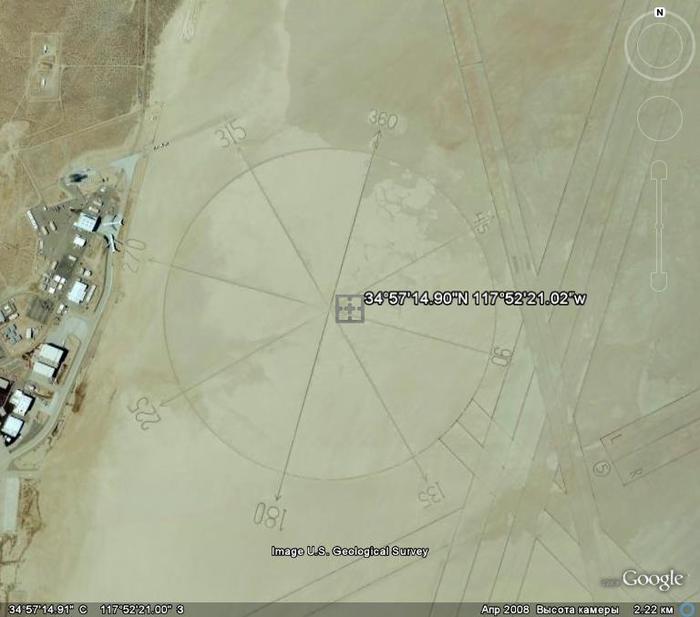
52°14"55.40"n, 4°26"22.74"eWho needs a compass at an altitude of 2 kilometers?
34°57"14.90"N 117°52"21.02"wArrows on the underwater bottom, which are visible only from a height.
32°40"36.82"n,117°9"27.33"e
The rocket flew and did not fly
38°13"34.93"n, 112°17"55.61"w
Ground drawing of some animal
31°39"36.40"n, 106°35"5.06"w
UFO landed in a grove
45°42"12.68"n, 21°18"7.59"eSight hundreds of meters in size
37°33"46.95"n, 116°51"1.62"wColorful lakes on the outskirts of Baghdad
33°23"41.63"n, 44°29"33.08"e
33°51"3.06"s, 151°14"17.77"e
Rock paintings in Oregon, visible from a height of 1.5 km
+42° 33" 48.24", -119° 33" 18.00"
Another triangle
-30.510783, 115.382303Apparently remnants ancient civilization under the water. Pay attention to the size of the building and the height of the shooting...
31°20"23.90"n, 24°16"43.28"wTurkey, Noah's Ark
The anomaly near Mount Ararat is a geological formation of an unusual shape. It is located at an altitude of 4725 meters above sea level and has a length of almost 183 meters. To date, there are three main versions that explain its occurrence - it can be a geological formation, a glacier, or ... the remains of Noah's Ark.
Among local residents there are legends about a huge old ship on top of a mountain near Mount Ararat. The writer Charles Berlitz in his book "The Lost Ship of Noah" cites the testimony of the Armenian Georgy Khagopyan.
George Khagopyan said that in 1905, as an 8-year-old boy, he was on Mount Ararat with his grandfather. And that they found the ark and went inside. On the upper deck, George saw a superstructure with many windows. The hull of the ark was huge and hard as stone.
The American magazine New Eden in 1939 published an interview with a former pilot tsarist army Russia by Lieutenant Roskovitsky, who allegedly discovered an object resembling an ark back in 1916 during a reconnaissance flight. Roskovitsky reported to the tsar, and Nicholas II equipped an expedition of 150 people. In two weeks they got to the object. According to Roskovitsky, the ship resembled a giant barge and a freight car at the same time, and inside there were many rooms - small and large. Moreover, the small rooms were covered with a metal mesh.
But the first significant evidence of the existence of an unknown object on top of the mountain is considered to be pictures taken by American pilots in 1949. A few years later, something resembling a ship covered in snow was seen by Turkish doctors. Then the object was photographed two more times: in 1973 it was made by the American spy satellite Keyhole-9 and in 1976 by the reconnaissance satellite Keyhole-11. CIA workers processing satellite images in the 70s found it difficult to interpret the data. Porcher Taylor, who at the time worked for the CIA, says that the picture was very unexpected. But he could not clarify what exactly was there, because the materials collected by Keyhole-9 and Keyhole-11 are still classified.
Coordinates: 39.440628,44.234517World Seed Bank on Svalbard
78°14"23.12"N, 15°27"30.19"ENeftegorsk - a ghost town, completely destroyed in 1995 after an earthquake measuring 9-10 points
52°59′45″n 142°56′41″e
Another strange building in the desert
30.029281,30.858294
An anomalous place near the city of Osoyoos in Canada - Lake Khiluk
49° 4"42.70"N 119°33"58.79"W
Ushtogai square
50 49"58.38N, 65 19"34.54E
- represents geometric figure consisting of 101 mounds in the form of barrows. The length of the side of the square is 287 meters! Approximately at a distance of 112 m from the northwestern corner, three rings with a diameter of 19 meters each are located diagonally.
On the opposite side, at a distance of 112 meters from the southeast corner there is an embankment with a diameter of 18 meters. If the square, rings and mound are a single figure, then the length of the figure is 643 meters!Obviously not natural origin building in Antarctica. Entrance to the dungeon
-66.603547, 99.719878
Four strange balls in Peru
13°33"39.26"s, 75°16"05.80"wUFO in area 51?
Larger
Chanquillo, Spanish Chankillo is an ancient monumental complex on the desert coast of Peru in the Kasma oasis in the Ancash department, Peru. Among the ruins are the hilltop fort of Chanquillo, the Thirteen Towers solar observatory, living quarters and public gathering spaces. It is assumed that the Thirteen Towers observatory was built in the 4th century BC. BC e. The area of the monument is 4 square meters. km. It is assumed that it was a fortified temple.
"Mandala" is the most mysterious geoglyph of the Palpa plateau, located 30 km from the more famous Nazca plateau. In addition to it, there are many geoglyphs on the plateau, it is a pity that in Google Maps(and Earth) they should not be seen properly. Geoglyph "Mandala" or Estrella (i.e. "star"), as the locals call it, is definitely the most amazing of them. According to scientists, it was created in the 2nd century AD. the Nazca civilization. The composition of two drawings has a size of about two hundred meters and the mystery, as you may have guessed, is how in ancient times people were able to create such a geometrically correct drawing, which can only be seen in its entirety from a bird's eye view. It is believed that the geolyphs of the Nazca and Palpa plateaus carry information encoded in mathematical form from their creators, whether they are people or someone else.
Several videos on this topic
Earthquake, plane crash, fire, Russian geoglyph, crop drawings and others interesting places planets. The coordinates of all places are given. In some places, to see what's on the video, you need to change the date (where google often updates the photo).
23° 6"54.45"N 113°19"3.79"E Game Center, China
35°38"6.01"N 139°44"40.63"E Tokyo Reclamation Center
33°26"19.18"N 111°58"51.41"W airport drawing, USA
35°41"18.90"N 139°45"19.90"E Tokyo Flower
45°38"27.65"N 122°47"43.01"W US crop drawings
52° 2"33.57"N 4°12"47.26"E Sundial, Netherlands
51° 3"16.04"N 1°58"42.45"W Medals, UK
52°31"15.93"N 13°24"34.08"E Berlin TV tower
37°47"30.27"N 122°23"23.57"W Bow and Arrow, San Francisco
35°46"52.68"N 139°35"59.27"E Note, Japan
54°56"30.29"N 59°11"35.85"E Geoglyph "Moose", Chelyabinsk
32°51"31.47"S 70° 8"31.76"W Highway, Chile
46°45"56.81"N 100°47"34.26"W Accident, USA
36°10"58.55"N 68°46"37.34"E Afghanistan (Afghanistan)
55°57"4.82"N 3°13"35.22"W Spiral, Edinburgh
23°38"44.11"N 57°59"13.14"E Heart Arrow House, Oman
34°55"29.03"N 139°56"32.84"E Fish, Japan
52° 9"14.17"N 2°14"53.03"W Frog, UK
43°42"53.23"N 112° 1"4.04"E Geoglyph giraffes of Mongolia
43°27"25.38"N 3°32"39.48"E Dinosaur, France
29°10"32.51"N 34°42"6.29"E sand pattern, Egypt
50°41"53.40"N 3°10"8.99"E Roof top car, France
39°44"57.08"N 105°0"23.02"W Pepsi Center, USA
42°54"6.25"N 22°59"31.76"E Medal, Bulgaria
35°42"13.37"N 140°50"21.12"E Aftermath of the 2011 Japan earthquake
37.790699,-122.322937 Plane crash- only google maps!
42°19"59.78"N 83° 3"19.94"W drawings, America
43°17"25.51"N 80° 1"42.35"W Field in Canada
51°56"57.39"N 7°35"25.43"E Dinosaurs at the History Museum, Germany
56°40"45.06"N 12°48"42.85"E 3 hearts, Sweden
52°30"36.12"N 13°22"19.99"E Sony Center, Germany
26° 6"57.47"N 80°23"48.39"W Boat City, USA
39°51"37.23"N 4°17"5.20"E secret place in Spain
69°10"36.03"N 33°28"27.51"E Capsized ships, Murmansk region
43°34"35.10"N 28° 9"4.00"E Pozhar, Bulgaria
52°32"15.37"N 13°34"28.10"E Labyrinth Germany
21°35"4.41"N 39°10"33.58"E "Space", Saudi Arabia
25°14"3.58"N 55°18"3.48"E balls, Dubai, UAE
33°36"6.59"N 111°42"38.98"W Fountain, USA
51°34"38.38"N 0°41"49.54"W Aircraft taking off, UK
53°27"5.16"N 113°44"4.84"W fig. in Canada, Formula 1
12°21"55.53"N 76°35"41.31"E INFOSYS lettering from residential buildings, India
53°48"49.58"N 3° 3"16.87"W Skull, UK (change date)
15°49"32.22"S 47°56"7.71"W Star, Brazil
51°58"14.47"N 4°12"1.03"E MiG 23, Netherlands
52°30"28.86"N 13°23"9.32"E Globe, Berlin
35°41"30.80"N 139°41"49.08"E Cocoon Tower Tokyo
55°24"0.17"N 10°23"7.93"E drawings, Denmark
40°35"44.02"N 141°24"27.53"E Fish, Japan
6°37"43.75"S 31° 8"10.10"E Hippo Lake, Tanzania
47°16"52.49"N 0°50"51.44"W French crop drawings
70°14"24.91"S 69° 6"25.56"E Strange object in the snow of Antarctica
33°49"46.31"N 130°28"4.68"E Sunken plane, Japan
59°57"16.63"N 30°20"15.96"E Cruiser "Aurora" St. Petersburg
25°11"46.30"N 55°16"36.87"E Burj Khalifa, Dubai, UAE, 828 meters. Burj Khalifa, Burj Dubai
3° 0"8.59"S 33° 5"24.30"E Tanzania market
66°17"50.90"S 100°47"7.55"E Ice begins to melt in Antarctica
67°25"48.55"S 60°52"35.18"E "Hand" in Antarctica)
40°41"21.15"N 74°2"40.34"W Statue of Liberty, USA
41°40"2.82"N 86°29"32.18"W Studebaker
41°45"39.13"N 86°16"9.39"W St. Patrick's Park, USA
44°58"1.39"N 124° 1"7.43"W bear
47°35"43.11"N 122°19"51.84"W Football match
48° 1"39.15"N 122° 9"50.93"W Maze, Washington
21°50"21.11"S 46°34"3.04"W in Brazil
28° 0"21.90"N 86°51"33.79"E Mount Everest Campground
29°50"36.13"N 47°50"49.45"E Fire
35°17"2.60"N 33°22"21.11"E Cyprus flag
44°45"39.41"N 20°28"19.73"E name former president Yugoslavia
44°34"54.07"N 38° 6"13.78"E Gelendzhik
48°48"18.82"N 2° 7"8.93"E Skeleton, Versailles
50° 3"8.21"N 8°36"51.04"E aircraft
50°56"17.25"N 5°58"40.80"E NATO Headquarters The Netherlands
52°19"36.22"N 4°55"11.33"E Newspaper Parking, Netherlands
52°25"50.72"N 4°23"24.12"E Boat and aircraft
51°17"6.09"N 30°12"44.47"E Chernobyl-cemetery of ships
69° 3"38.05"N 33°12"18.76"E Nuclear submarine "Kursk"


1. Baker Lake, Inuit territory in northern Canada 
The man, who identified himself as "Dr. Boylan", believes that the darkened area in this picture and in several other locations hides extraterrestrial beacons of aliens.
2. Ramstein Air Force Base, Germany

This NATO air base is the starting point for Operation Iraqi Freedom forces, and for this reason, it can certainly be a target for terrorist attacks. This may explain why this feature is partially cut from Google Maps.
3. Pacific Northwest, USA

What exactly are we not seeing in this photo? This place is located near the border of the states of Washington and Oregon. Enthusiasts personally examined this place and found nothing remarkable, except for the sinister appearance of the fence and the unmarked entrance.
4. Shazalombatta Oil Refinery, Hungary

This is one of the strangest examples of censorship in Google Maps - this place is simply painted over in green. The factory area has been removed, the buildings have been erased, and all you can see is regular grass.
5. Huis Ten Palace, Holland

It is hard to imagine that the Dutch The Royal Family can be main goal for a crazed terrorist, however, Huis Ten's royal palace is heavily blurred on Google Maps when viewed from any angle. (However, the surrounding area and trees can be seen with crystal clarity at close magnification.)
6. Unknown zone, Russia

No one knows what is hidden in this region. One of the opinions is that there is " radar station or a missile interception system”, and some claim that the image of the surrounding area is pasted from another region of Russia.
7. Mobil Oil Corporation, Buffalo, New York, USA

Some criticize Buffalo-based Mobil for blurring images of its operations, saying that oil corporations are not of much interest to terrorists. On the other hand, we do not know what the terrorists themselves think.
8. North Korea

Everyone has heard of this country, which is part of the supposed "Axis of Evil", but very few have ever visited it. You won't see it on Google Maps either, as the entire country exists in the imagery, but without road markers, street names, or any other identifying details.
9. Reims Air Base, France

The reasons why this air force base is blocked from Google Maps are unknown.
10. Indian Point Power Plant, New York, USA

Many members of the United States government called for a shutdown of the Indian Point power plant. Environmental considerations aside, according to energy experts, the power plant is not strong enough to withstand an earthquake like the one that recently devastated Japan.
11. Volkel Air Base, Holland

It is rather amusing to see how this air base is grossly blurred on satellite images, however, WikiLeaks has published diplomatic correspondence that confirms the presence of nuclear warheads within this base.
12. HAARP, Gakona, Alaska, USA

HAARP (High Frequency Northern Lights Research Program) is one of the most controversial operations currently underway in the United States. Gakona, the site of research, and the ionosphere experiments there, are revered by some conspiracy theorists as the cause of everything from floods to earthquakes, but there is very little evidence for this.
13. Mazda Laguna Seca Raceway, Salinas, California, USA

This is one of the strangest examples of censorship on Google Maps: the Laguna Seca race track in Salinas, California. The strangest thing about this is the fact itself: this is an apparently harmless race track.
14. Babylon, Iraq

While the surrounding area is perfectly visible, the city of Babylon itself is blurred in the pictures. One can argue that this has something to do with the rebels there ...
15. Tantauco National Park, Chile

Why is this endangered species sanctuary completely cut out of Google Maps? Nobody knows.
16. The Hill, Elmira Correctional Facility, USA

This is a prison top level reliability in New York State. Perhaps, after the riots in the Attica prison and several incidents of uprisings and mass escapes around the world, the authorities may indeed be worried about the possibility of escapes using helicopters.
17. House of Alexey Miller, Russia

According to Wikipedia, this place is the "private palace of the executive director of JSC Gazprom Alexei Miller." But why is he given preference over all other people? Maybe we're just not powerful enough to convince Google to cut out our homes from satellite imagery.
18. Colonel Sanders

This is the strangest fact from Google: Colonel Sanders, the face of the Kentucky Fried Chicken chain, does not appear in any of the Google Street View images. This is because, according to Google representatives, Sanders was real person, and images real people should be blurry in any shots.
19. Faro Islands, Denmark

It is believed that in this zone there are some non-advertised military installations.
20. NATO Headquarters, Portugal

This shot would be the funniest if it didn't have such an ominous context. Whoever edited the picture of the Portuguese headquarters of NATO just copied another section earth's surface over the image of the building. Very strange.
21. Seabrook Nuclear Station, New Hampshire

It is believed that in this northeastern part of the United States is nuclear power plant Seabrook.
22. Missile mine, Spain

According to one researcher, “At this place is small building with what looks like a missile silo in the middle. What is strange is that this area is not blocked in Yahoo! Maps, but its image is not Google Maps.
23. Nuclear zone, France

We're not entirely sure what "The Marcoule site of the Commissariat l'Energie Atomique" means, but we think "atomique" is the key here.
In contact with
Looking at photographs of our planet taken from space, you can find a lot of intriguing and sometimes inexplicable things, especially if you connect your imagination while viewing.
Bright Side collected mysterious objects and places that users found on google maps.
Wasteland Guardian

In November 2006, Lynn Hickox discovered on Google Maps a geological formation located in the Canadian province of Alberta, resembling an Indian head with an earpiece in his ear. Such an image appeared as a result of prolonged soil erosion, and the wire from the earphone and the ear - the road leading to the oil rig, and the rig itself.
Blood lake in Iraq

In 2007, near the Iraqi city of Sadr, a blood red lake. Versions of the origin of the anomaly were very different - from Wastewater to the waste of a nearby slaughterhouse. But the reason for this color of water has not been established. Today the lake looks just like the others.
Heart shaped island

Galeshnyak Island , belonging to Croatia, was discovered on satellite maps in 2009. The island quickly became popular, not only on the Internet, but also among travelers - before that, an uninhabited part of the land turned into a place of pilgrimage for lovers from all over the world.
Fingerprint labyrinth

Labyrinth in the shape of a print human finger, made of limestone tiles, is located in Hove Park in Brighton, UK. It was created in 2006 from a sketch by artist Chris Drury.
"Murder scene" on the lake in Almere, the Netherlands

A satellite image taken in 2009 in the Netherlands was discovered by one of the users of the Reddit website. The scene seemed like a murder, and there was a heated discussion on the site about what it really was.
However, no bloody crime was recorded in this picture. Almere resident Jacqueline Kenen identified the brutal "killer" as her golden retriever, who she says loves to swim. And what was taken for traces of blood is actually just water that has been glassed from the dog's fur.
Building in the shape of a swastika

The swastika-shaped building belongs to the US Navy and was spotted by Google users in 2006. The command of the Navy said that the similarity with this figure was discovered only at the construction stage, when nothing could be changed.
In 2007 $600,000 was allocated to change the landscape and install solar panels so that they hide the shape of the building. As of 2017, thanks to solar panels, the building no longer resembles a Nazi symbol.
People in dove masks

This street shot was taken in the Japanese town of Musashino in March 2013. This "composition" was built on purpose - the users and the site team Daily Portal Z having learned that the streets will be photographed for Google decided to immortalize itself on the map.
A ship overgrown with trees

This derelict and tree-covered ship was captured by satellite on the Parramatta River near Sydney, Australia. The ship named SS Ayrfield was launched in 1911. In 1972, she was decommissioned, and since then the ship has been moored at the mouth of the river.
UFO in Romania

An object that looks like a UFO from science fiction films has been found on an abandoned farm near the Romanian city of Timisoara. The discovery gave rise to a lot of rumors about the visit of an alien ship to Earth. In fact, a flying saucer is abandoned water tower, which used to supply Timisoara with water.
Desert breath

Strange circles in the Sahara Desert were created in 1997 by the hands of people who are members of the creative association D.A.S.T. The sculpture was made of two spirals emanating from the center, one of which was created from cones expanding as they moved away from the beginning, and the second from recesses built according to the same principle.
According to the creators, the spiral should disappear over time under the influence of erosion. However, even now, 20 years later, it is perfectly visible even from space.
Military Aircraft Cemetery

Davis-Monten Air Baseis located near the city of Tucson in the United States and is perhaps the world's largest place for the preservation of aircraft - about 4,400 aircraft and 40 spacecraft are laid up here. Every year, about 400 pieces of equipment come here and the same number is sold or destroyed.
Strange Creature from Loch Ness

Jason Cook, 25, was looking at satellite images of Loch Ness when he spotted a creature swimming in its waters. And although there is no reliable evidence of the existence of the famous monster, many believed that it was the Google satellite that captured it.