Mouth of the Okavango. Okavango flowing into the desert. Meeting with the "forest man"
The Okavango River is capricious. It would seem, starting only three hundred kilometers from Atlantic Ocean, that’s where it should direct its waters. But no, the Okavango turned away from him, as if another ocean, the Indian Ocean, was attracting it, thousands of kilometers away in the southeast. But the river cannot reach it: the greedy sands of the Kalahari dry it up completely, without a trace. However, before sacrificing itself to the fire-breathing desert, the Okavango floods widely, forming the largest inland delta in the world.
A little geography
 The Okavango Delta stretches over twenty thousand square kilometers, giving shelter to fish, birds and predators, and - last but not least - humans. It's hard for a man to get through dense thickets papyrus covering the shifting swamps. The expanses of the delta remain virgin - its numerous islands and islets. Many of them owe their existence to hardworking termites: in dry times, they build high termite mounds and loosen the soil into which plants then take root.
The face of the delta is constantly changing - with every year and season. And the reason for this is the river itself and its original inhabitants. Termites build islands, and hippos build channels to the islands - places of new pastures. Rare visitors to those remote places make their way along these channels, through the reeds. The only means of transportation is native pirogues hollowed out from tree trunks - “mokoro”. Thanks to their narrow, elongated body, they can move among papyrus thickets, however, if the thickets are not too dense.
The ease with which other species of flora and fauna adapted to life in the delta (which I witnessed) and in the arid, almost waterless conditions of the central Kalahari is amazing.
When people talk about the Kalahari, the phrase that usually comes to mind is “dead desert.” Desert - yes, but dead - no. There is water and, accordingly, life. That's right: the water is hidden under the thickest sand cover in the world, stretching over a distance equal to the space between the Urals and Poland. Plants resort to whatever tricks they can to get to the precious moisture and prevent it from going even deeper. The densely intertwined root system of grasses retains rainwater. The roots of some acacias go to a depth of 30 meters. Large root vegetables manage to accumulate up to 10 liters of water. These tubers are not hidden very deeply, and, for example, springbok antelopes, tearing them out of the ground and eating them, perfectly quench their thirst, even far from water bodies. Predators do the same thing: they get water from the body of their victims.
Another source of life-giving moisture in these parts is rain. But he does not often bestow the desert.
Two seasons are typical for the Kalahari - dry and rainy, although in the usual sense they cannot be called seasons. The dry period lasts from May to October; rainy - from November to April. However, the word “rainy” can be put in quotation marks, since it hardly rains at this time. And if the drought continues for several years in a row, then both animals and people suffer. But as soon as life-giving moisture pours from the skies, a significant part of the Kalahari is transformed. Grasses appear over vast areas, dry lakes fill with water, attracting colorful flocks of birds; animals scatter over many thousands of square kilometers. It is not for nothing that in Botswana the same word is used for both the monetary unit and the greeting: “pula”, which means “rain”.
However, what happens in the delta is partly independent of local atmospheric conditions. The Okavango originates in Angola and flows for hundreds of kilometers through mountainous terrain. In the mountains of Angola, during the monsoon period, usual for those subequatorial latitudes, a lot of moisture accumulates, and the Okavango regularly carries it to the delta itself - after one and a half thousand kilometers.
Due to the flat nature of the terrain and the width of the delta, the river flows slowly - at a speed of up to one kilometer per day, so it also overflows slowly. And it takes almost five months for new water to cover the distance from the upper reaches of the delta to its lower reaches, where it gradually disappears into the sand. It goes away - but not completely. The Okavango, as if unwilling to give up, gathers its last strength - and a tiny stream flows further through the Kalahari, albeit under a different name - Botletle. Thus, the rainwater that feeds the Okavango in the Angola mountains reaches the lower delta in about six months - right at the height of the dry season in Botswana. And the water in the delta is crystal clear: it flows slowly through papyrus and reed thickets - a kind of “filters”, and is therefore suitable for drinking.

Maung
Almost in the very heart of the delta is the town of Maung. Once upon a time, a small village huddled in its place, and this could not but affect the colorful appearance of the city. Next to the tall, modern telecommunications center building, there are characteristic African huts, the so-called “rondavels.” Powerful diesel engines rumble on the embankment, where, according to stories, crocodiles sometimes get out and devour careless onlookers - several people a year. On the streets among passers-by dressed in ordinary clothes summer clothes, you can often see herero in wide skirts, which are more suitable for ballroom dancing than for walking on the sands of Maunga. The Herero tribe once adopted this strange fashion from German missionaries and are now extremely proud of their dress.
But one thing the residents of the town are united in is their hospitality. Everyone here is friendly, both black and white. This may be because Botswana has escaped the worst forms of British colonialism and Cecil Rhodes' apartheid in other countries in southern Africa at the end of the last century. People different colors skins here really live in friendship. I was convinced of this myself when I attended a meeting that took place in Maunga. Members of the meeting discussed issues of hunting and water rights to Lake Ngami, located south of the Okavango Delta.
The fact is that the shores of Ngami are a true animal kingdom... when there is water in the lake, of course. During drought, Ngami dries up to the very bottom.
Now life was in full swing there. However, despite the abundance of living creatures, hunting had to be done according to the rules. It is clear that hunting is an important source of food for local residents. But even for them, restrictions had to be set - you can’t exterminate animals indiscriminately! Not to mention foreigners: maybe they should be banned from hunting altogether? However, from an economic point of view, this would be unreasonable, since visiting white hunters are wealthy people and for a trophy - for example, a zebra - they are ready to pay ten times, or even a hundred times more than they are able to pay for the right to hunt that the zebra is a local resident...
Where and how much water can be diverted so as not to upset the ecological balance in the Okavango Delta?..
In general, the meeting lasted several hours. There were both whites and blacks in the hall and presidium; a white woman presided - she was also a translator. It was clear that English language understandable to everyone, but some speakers spoke their native Tswana, and then the floor passed to the presiding translator. It was also clear from the speeches that the whites were citizens of the Republic of Botswana. As far as I have been able to find out, in Botswana no one and nothing can force whites to take citizenship - not the government, not the circumstances. Moving here from other countries, they completely voluntarily become citizens of a “Negro” state, which is not at all typical for whites in other African countries.
To be honest, I was not so much interested in the issues being considered, which were essentially incomprehensible to me, a stranger, as in the people themselves - the expressions on their faces, their temperament... The opinions of both whites and blacks were treated here with equal attention and respect. Of course, there were disagreements, but during the entire time spent in the hall, I did not hear a single sharp attack - no one even raised their voice. In general, I left the meeting with a joyful feeling in my soul...
Sitatunga and others
And the next morning a small plane took me and my three companions from Maung to a tent camp located near blue waters a bay bordered by thickets of papyrus. The camp was equipped with everything necessary - in a word, complete comfort. True, it was occasionally disturbed by the tedious buzzing of tsetse flies. But here no one panics because of them. These inconspicuous-looking dipterans sting quite painfully, but only one in a thousand flies turns out to be a carrier of sleeping sickness. In addition, thanks to spraying, which is carried out under the supervision of caretakers national park, the number of tsetse in the delta for last years decreased significantly. So on the first night, having chased a couple of annoying insects out of the tent, I happily indulged in a peaceful sleep.
In the morning, throwing back the flaps of the tent, I saw a whitish veil of fog, chest-high - another climatic feature deltas.
Plunging into the pirogue, we set off. The Mokoro, skillfully steered by Manila, my guide, slid along clean water, then through the reeds - and almost every ten meters, new landscapes opened up before us. Water lilies, blooming after a night's sleep, exposed their delicate petals to the morning light. The foggy curtain gradually dissipated - visibility gradually improved.
Something was fluttering in the papyrus thickets: it looked like we had scared away some large animal.
“Sitatunga,” Manipa said, as if I understood what he was talking about.
- Such a big animal, how can it run straight through the thickets, and even through the water: it’s not shallow here? - I asked the conductor.
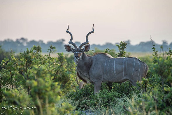
“Not by water,” Manipa clarified. - This antelope is stomping right on papyrus... of course, relatively thick. Walking through unsteady places, she spreads her elongated hooves wide. Sitatunga even raise their cubs on papyrus islands where predators cannot reach them.
“I’ve never heard of such an antelope,” I muttered in surprise.
- We are located on the territory of the reserve - this is the only place where you can see them. But in other places they are rare. Maybe that's why few people know about them.
“It’s a pity, I didn’t see her well.” And what size are they?
“Nowadays it’s generally forbidden to hunt sitatung, but before, my father sometimes brought them home and sold the meat. Some weighed more than eighty kilograms.
- Eighty kilos - and on water as well as on dry land.
- I'm sorry, what? - Manipa didn’t understand.
“Nothing,” I say, “it’s just me...
Sometimes, to shorten the path, Manipa would direct our sharp-nosed “mokoro” through the thickets to some island. On the islands the grass had already turned yellow, although in some places it was still tall. It attracted fast antelope impala, and from afar we were looked at sternly by large, gloomy wildebeest, which are called “wildebist” - a word borrowed from the Dutch language, which means “wild beast”.
Having moored to the shore, we entered the grove, and then larger herbivores appeared.
The terrain resembled an ordinary African savannah: bushes and trees gave way to steppe, then again to a grove. Trees attract animals: in open space they are clearly visible. The first ones we saw in the grove were black, or African, buffalos. The African buffalo is very different from its Asian relative in its ferocity and unpredictability. He tends to attack suddenly, which is explained by his myopia. Not seeing well what his “probable” opponent is doing, the buffalo sometimes rushes at him out of the blue, following the principle “attack is the best defense.” Whether this is true or not, but the “blackie” is definitely more dangerous than a lion who is usually indifferent to people.
A herd of buffalo trampled in the distance, but then a large male appeared less than a hundred meters from us and, seeing us, froze in anticipation. Manipa didn't like this.
“Let’s stop and let’s not tease him,” he whispered. “Who knows what’s on his mind.”
For a minute that seemed unusually long, we stood motionless, playing staring contest with the buffalo staring at us.
- You know, you better climb a tree. “The guide pointed to a tree standing nearby, on which there was only enough room for one.
- And how are you?
“It’s okay, I’ll guard you down here.”
Without asking what he meant by the word “guard,” I obeyed the order and somehow perched myself in the place where the tree trunk forked. Just then I remembered about the camera... But the next moment the picture changed: two “ladies” appeared on the stage, whom our gallant gentleman, apparently, considered it his duty to protect. Paying no more attention to us, he disappeared into the bushes with them.
“Come on, hurry up and get down from the tree and get into the Mokoro.” Now we’ll go to Chief Island - you’ll see elephants, lions, and maybe hyenas.
We went around Chief from the western side along a narrow channel that divided this neighboring island. Suddenly loud splashes and squelching were heard ahead, and some kind of fuss began.
“This is an elephant,” Manipa assured me. - Or maybe not alone. Let's stop and take a look...
Returning from reconnaissance, a somewhat embarrassed Manipa reported that a large elephant had lain down to rest on the bank of the channel and even blocked it a little. So it’s hard to say when he will deign to clear the way for us.
And then he added:
“Although it’s generally possible to walk there.” But if we suddenly appear so close to him, the elephant may get scared, and then only chips will be left of the “mokoro”, and a wet place will be left of us.
- Well, let's go back the other way, there are many different channels here...
— Weight is not so simple. To the right, behind this nameless island, our path will be blocked by an impenetrable papyrus plug. It's too far to go around Chief on the east side. We won't make it to camp before dark. And the sun sets at six. Can you imagine what it's like to be in this labyrinth in pitch darkness? Then they won’t pat me on the head for this.
- What if you scare away an elephant from a distance? - I suggested. - Maybe he will get up and leave?
“So he won’t pay any attention to us,” Manipa remarked reasonably. - If we get close, we might run into...
- That’s the situation! What to do?
- There's only one thing left to do - have a snack. This brilliantly simple answer puzzled me a little.
- Have a snack? Well, we already had breakfast...
“So we’ll have to have lunch.” Manipa was young, strong, and could grind breakfast, lunch, and dinner at once without blinking an eye. With the dexterity of a real waiter, he quickly arranged folding chairs, a table and laid out all sorts of food. Opening a thermos of tea, I suddenly stopped and asked:
- What if this thug comes to us for a cup of tea without an invitation? This is not your buffalo. For example, he will break this tree like a match if we climb on it.
“Of course, he’ll break it,” Manipa agreed dispassionately. - But why on earth would he break it?
- Why, elephants break down trees all the time!
— They break to get to the branches on which they feed. Elephants don’t just attack people - only in cases of obvious threat. True, there are exceptions - solitary elephants. Among them there are real monsters. They mainly attack. But this rarely happens. So pour some tea and don’t be afraid - the elephant won’t try to kill you.
Having finished our meal, we, like clean housewives, went down to the stream to wash the dishes. Either our noise disturbed the giant, or something else, but he suddenly stood up. Manipa told me to lie down in the mokoro, and he hid behind the boat. And we began to wait for what would happen next. To our relief, the elephant crossed the channel and began to climb the steep bank of Chief Island. He stopped there, turned his back to us... and did not notice how we quietly slipped past.

The biggest lions
Manila felt indebted to me, promising to show me a lion and a hyena during our walks, but, alas, nothing came of it: we never saw the hyenas, and I only saw half of the lion. The other half of it - the head and the front part of the body - was behind the bushes, and I could only guess that it was a male.
“Exactly a male,” Manipa assured me. - Just look at his paws. In Botswana we have the largest lions in Africa. They attack buffaloes and even young elephants in packs. And they retreat only in front of one enemy - hyenas.
- Hyenas? - I was surprised. - But lions are incomparably stronger and larger.
- Yes, they never fight one on one - hyenas run away cowardly. But when hyenas gather in a huge pack, it’s still a question of who will win. It happens that lions shamefully flee...
In the end, we were lucky: during our next trip to Chief Island, we clearly saw a lioness devouring a wildebeest.
“Now we have much more wildebeest in Botswana,” continued Manila. “And a few years ago, during a long drought, it was simply terrible what was happening. Wildebeest died in the hundreds of thousands, all because of fences.
Manipa was referring to the fences erected in various places in Botswana to protect livestock from wild herbivores, carriers of contagious diseases that can be transmitted through food to people: foot and mouth disease is especially rampant - and often fatal.
“Fences,” stretching hundreds of kilometers across the Kalahari, fenced off large pastures where herds of buffalo, wildebeest and other antelope grazed in non-drought times, from perennial water sources - and especially the delta. But then a long-term drought struck - this had happened before - and herds of thousands began to migrate along the familiar route to the north, to the water.
The main tragedy occurred in the depths of the Kalahari, south of the delta. The fences helped the delta itself a lot. On the western side they stopped the herds of cattle. Without the fences, livestock would invade and devastate the delta's water meadows, leaving wild animals to die out.
Now the delta is full of life - on land, in water and even under water, which greatly frightened one of the families of our camp. A father, mother and their sixteen-year-old daughter once went for a walk in two mokoros. Piroga with her dad and mom safely came out of the bay near the camp, but something happened to the boat where the girl was sitting. “Mokoro” suddenly jumped on the spot - the guide and passenger found themselves in the water, and the boat in the mouth of a hippopotamus. Having bitten off a piece from the side and rendered the pirogue unusable, the hippopotamus disappeared under the water. The other mokoro was already some distance away. The frightened parents expected with horror that the monster would emerge again and their daughter would end up in its mouth. The guide and the girl, as if racing, swam to the shore, which, fortunately, was close.
The frightened guide explained that nothing like this had ever happened here, near the camp itself, before, but in other places such incidents are still happening - sometimes with human casualties. The fact is that hippos like to graze at night, and in daytime When it's hot, they prefer to relax in or under water.
That same day, the unlucky family left the camp, leaving the following entry in the guest book: “The place is interesting, but very dangerous.”

Meeting with the "forest man"
I often pestered Manipa with questions about the Bushmen. I was interested in the past and present of this people, which differs from most other African peoples not only in their external, physical appearance, in particular, skin color - they have much lighter skin - but also in a number of linguistic features; anthropologists even attribute them to some kind of special race .
Bushmen (Bushmen, translated from English as “bush people.” - are divided into groups: Kung, Kong (Makong), Khomani (Nusan) and others. - Note edit.) and the Hottentots, the original inhabitants of South Africa, settled here long before the arrival of the tribes of the Bantu linguistic group that now inhabit these places. Even before the establishment of white rule, the Bantu ousted the Bushmen from best areas Kalahari to barren areas. But even there the “forest people” showed extraordinary ability to survive, adapting to find water and food in an environment hostile to humans.
However harsh conditions lives and constant persecution of foreigners greatly reduced its numbers. Although today the Bushmen are allocated special settlements in the Kalahari, or, simply put, reservations, they practically do not live there: the majority prefer to engage in hunting and gathering - that is, to lead the traditional lifestyle of nomads. The rest are employed by the same blacks and whites.
- Why are you interested in the Bushmen? - asked Manipa.
“I’ve heard a lot about them and would like to see where and how they live.”
- How do they live, you say? Badly. But, if you want to look at them, we can go to the village, at the very end of the delta.
The skin color of the Bushman with whom Manipa introduced me was, indeed, not black, but apricot color, but otherwise, in appearance, our Bushman was not much different from other Africans. What was surprising was his suit: a jacket and trousers of dark blue with white stripes. Such a couple would be more likely to be seen at a diplomatic reception than on a farm worker in the wilds of the Okavango. The suit was clearly from someone else - unbuttoned, too large, the jacket hung strangely on his thin naked body, exposing protruding ribs. When I asked if he was getting ready for a parade, the bushman replied that the suit was given to him by a visiting European, and he was wearing it because now he had no other clothes left.
Then, looking me up and down, he suddenly asked:
— Could you give me a shirt? It's winter time now. And although the days are hot, the nights can be cold.
Unfortunately, I could not satisfy the request of the “forest man”, since I took with me on the road only the most necessary things. And I left everything else in Maung. But I still promised to send him some clothes from the camp when I fly back to Maung.
“Tell me,” I turned to my new acquaintance, “do you have any relatives among the Bushmen nomads in the Kalahari?”
“What kind of relatives are there?” he answered sadly. - Those who were there died long ago. We had such a custom - in Hard times leaving the weak and old to die in the desert to save food and water for the stronger. The old people themselves asked to be abandoned.
- But is there anyone left alive? - I was amazed.
- Yes, sure. Those of my family who survived now work on farms, like me and my brother.
Then his brother came up to him and they started talking in native language. I noticed that during the conversation they somehow smacked their lips, but then I didn’t pay much attention to it. Later I learned that smacking is characteristic of a peculiar family of so-called “clacking languages” common among the Bushmen and Hottentots. There are several types of clicking sounds - they all perform the functions of consonants (Linguists, powerless to designate these sounds with letters, use to designate them exclamation marks and colons in the middle of a word. For example, “tzwa! na". — Note edit.).
The culture of the Bushmen - their songs, dances, rock paintings - has now fallen into decay. 90 kilometers from our camp there were heights rare in the Kalahari - the Tzodillo Hills, dotted with rock paintings. These are very well done ocher images - mostly wild animals, and sometimes people. There are a lot of drawings, maybe more than a thousand. Who created them? The Bushmen living near Tzodillo have no idea about this...
But, in general, I have a pleasant impression of this country, because people here build their lives in a civilized manner, without racial hostility, and diligently protect the unique gift of nature, the Okavango Delta, which flows into the sandy Kalahari Ocean.
Vadim Dobrov
Botswana
Seasonal rivers drying up in Africa or in deserts on other continents will not surprise anyone, but this is a special case. In all respects, the Okavango is not an oued, but a normal river that does not even think of drying up during the dry season. It quickly rushes along a narrow rapids channel with the savannah-covered banks of the Angolan plateau of Bie down in a south-easterly direction; Before the border with Botswana, it overcomes the waterfalls that form a cascade of Popa waterfalls, blocking its entire width, which in this place is 1.2 km. Only on the plateau does the river acquire a flat character.
As the slope decreases, the Okavango slows down and spreads out, spreading through a labyrinth of branches, lagoons and lakes that form the world's largest inland delta. The Okavango has a solid annual flow at the mouth; about 10 thousand km 3 of water flows into the delta annually, but... The river’s path usually ends at this gigantic delta. The Okavango does not flow into a lake, nor into another river, nor into the sea, nor into the ocean. “Where does all this water go? It’s just some kind of mysticism!” - exclaimed one of its researchers in the 19th century. In fact, where?
During high water, the southern branch of the delta feeds the freshwater Lake Ngami, the northern branch periodically, once every few years, reaches the Kwando River, a tributary - and then the Okavango briefly finds access to the Indian Ocean. And the Botletle sleeve occasionally feeds salt Lake Tskau on the southern edge of the swamps, formed during the rainy season on the salt marshes of the Makgadikgadi drainage basin. But this is no more than 5% of all water entering the delta.
The Okavango was once part of a large river system of the ancient Lake Makgadikgadi, which supposedly had an area of 80 thousand km 2 and a depth of 30 m, but gradually dried up about 10 thousand years ago.
The residual reservoirs of the Okavango Delta are almost all that remains of the huge lake. Now in its basin during the dry season there are huge lifeless salt marshes with a cracked salt crust (very large reserves of potash), and during the rainy season two large salt lakes are formed in the depressions and life is in full swing there: animals come, birds fly in, in some places the shores seem pink from thousands of flamingos. Rarely, once every 10-15 years, these lake-swamps are connected to the Okavango Swamp through one of the branches of the Botletle delta during the rainy season.
Recent studies have shown that of the total mass of water that annually enters the shallow, flat marshy Okavango delta, about 60% is absorbed by plants (thickets of papyrus and shrubs, algae, water lilies, lilies, etc.) and 36% evaporates from the water surface. Approximately 2% goes into the ground, and another 2% feeds Lake Ngami in high-water years. But this is not enough for the “blue heart” of the northern edge of the Kalahari Desert, and Ngami gradually dries up, gradually decreasing in size and turning from a fresh lake into a soda brine sump, with stripes of shallows and white shores.
And the Okavango Delta, which occupies an area of about 15 thousand km 2, and after the summer rains during the flood, all 22 thousand km 2, is not going to dry out and provides shelter for many birds and animals. In the northeastern part of the delta it is organized large nature reserve wildlife Moremi (Botswana).
In the upper reaches, the Okavango River (Cubango) flows from the Bie plateau onto the plain - fast, narrow and rapids. Then it acquires a flat character and flows calmly, but before the border with Botswana its channel along the entire width of 1.2 km is crossed by waterfalls (in the dry season they protrude above the water), forming Popa Falls. After them, the river’s edge drops by 4 m. In the lower reaches, the river gradually slows down as it approaches the northern edge of the Kalahari Desert.
The shallow, swampy and flat (elevation differences of less than 2 m) river delta, also known as the Okavango Swamp, forms an oasis with richest variety flora and fauna. This is where the path of the water flow usually ends.
On a map of northwestern Botswana, the inner Okavango delta, with its central swampy area and branches, resembles the shape of an open palm extended towards the Kalahari.
The Okavango is the only permanent river of the vast Kalahari Plain, located between the Zambezi Rivers, and in South Africa. On maps it is usually designated as the “Kalahari Desert”. But these places are not like the Sahara or the deserts of Arabia; Compared to them, it is not even quite a desert. In summer, the Kalahari experiences heavy rainfall, ranging from 250 mm in the south to 1000 mm in the north of precipitation per year. In addition to one permanent river, there are also temporary rivers and lakes (most of which, however, dry up in winter). Trees, shrubs and grasses grow in the Kalahari, and in large quantities. Therefore, scientists cannot agree on what is more correct to call it: “desert savanna”, “green semi-desert” or, perhaps, “steppe park landscape”. Sometimes on maps its central sandy region is distinguished as the “Kalahari Desert”, and its outskirts as the “Kalahari Basin”. And the vast green wetlands of the shallow, flat Okavango Delta amid the sands of the northwestern sector of the Kalahari Desert are called the world's largest oasis. In terms of its importance for southwest Africa, the Okavango is no less important than the Nile for the northeast. The life of all inhabitants of the surrounding area directly depends on their waters.
The Okavango swamps are teeming with all kinds of wildlife all year round. Here, in this giant green oasis, overgrown with reeds, bushes, water lilies and algae, elephants, giraffes and antelopes, lions, leopards and hyenas and many others come from afar to drink. It is a paradise for waterfowl, hippos and all kinds of insects...
Archaeological finds confirm that people have continuously lived in the lower reaches of the Okavango for 30 thousand years, but there have always been few of them: perhaps precisely because of insects that carry malaria, sleeping sickness and other tropical ailments. Nowadays, the banks of the river are mainly inhabited by Bantu peoples, including those who gave the river its name, the Kavango. Also living here are the indigenous peoples of hunters and gatherers - the Bushmen ( common name), who inhabited South Africa long before the Bantu migration. The Tsodilo Hills, west of the Okavango Delta, are a sacred place for the Bushmen and their ancestors, with many legends associated with this place and the firm belief that the ancient gods still live in caves painted by their ancestors with thousands of Stone Age rock paintings.
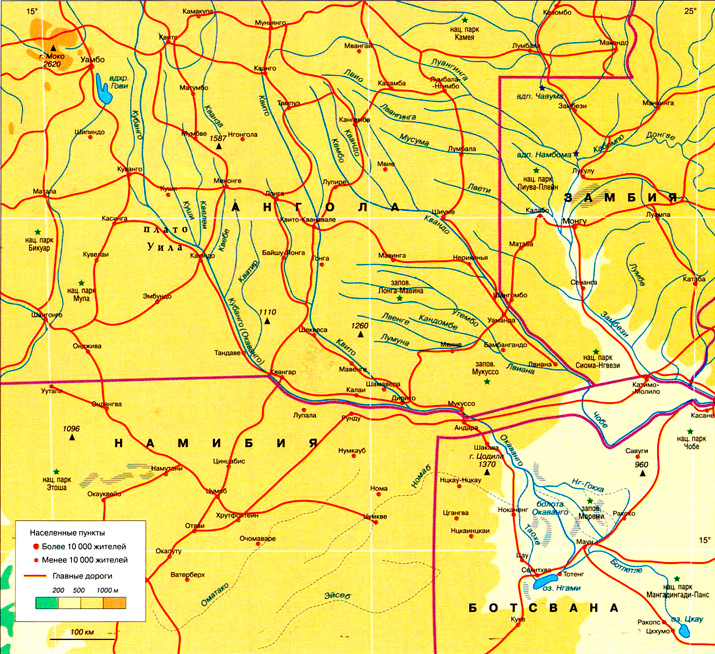
The Okavango in its upper, middle and lower reaches is divided between Angola, Namibia and Botswana. Moreover, they are dividing in the literal sense, seriously conflicting over water and river resources that are precious in arid areas (these territories suffer from drought). Although there is practically no economic activity directly along the banks of the river (due to which, by the way, the water in the river is very clean), Angola and Namibia are trying to save the situation of existing farms: the first - through the construction of a dam, the second - through the already built water diversion canal and the planned pipeline construction. Botswana is home to a delta famous for its rich wildlife, huge contribution Ecotourism in the Moremi Nature Reserve and the organization of safari bring into the state treasury, so the local government does not intend to lose such an important source of income due to the threat of water shortage and, as a result, impoverishment of flora and fauna. So now controversial issues A special commission decides on water consumption between neighboring countries.
general information
A river flowing inland and flowing into the Kalahari Desert.Location: southwest Africa, flowing from the Bie plateau in Angola to the southeast, ending in a vast marshy delta on the northern edge of the Kalahari Desert.
Feeding method: mainly rain.
Basin: an area of internal drainage that does not empty into any ocean.
Source height: 1780 m above sea level (Bie plateau).
Estuary: Okavango swamps (700-1000 m above sea level), formerly Lake Makgadikgadi (dry).
Other names: Cubango (in Angola).
Largest influx: Quito (left).
Flows through the territory: the upper course in Angola, 400 km to the south serves as a natural border between Angola and Namibia, then flows through the territory of Botswana.
Numbers
Length: 1600 km - 4th longest in South Africa.Width: narrow in the upper reaches, up to 20 km closer to the delta.
Pool area: 721,258 km 2 .
Delta area: about 15,000 km2 (up to 22,000 km2 during the rainy season) - the largest inland delta in the world.
Average water consumption: 475 m 3 /s.
Water flow at the mouth by season: 100-200 m 3 /s in the dry season (November), about 1000 m 3 /s in the rainy season (March and April).
Annual flow: about 10,000 km3.
Solid runoff: about 2 million tons per year of solid sediments (sand, etc.) and another 2 million tons per year of dissolved salts settling in the delta during the evaporation of moisture.
Water level: drops by 4 m after Popa Falls (before the border with Botswana).
Climate and weather
The Okavango Delta is a kind of oasis with a special microclimate, very different from the surrounding tropical arid climate.Hot and humid rainy season: December - March (humidity 50-80%, up to 40°C during the day, warm nights).
The most comfortable period: March - early June (about 30°C during the day, cool nights).
Dry and cold season: June - August (warm during the day, night temperatures can drop to 0°C).
Dry and hot season: September - November.
Average annual precipitation: 450 mm.Economy
The banks of the river are sparsely populated; There is virtually no agricultural or industrial activity along the Okavango, so the water is very clean.Agriculture: subsistence farming, hunting and gathering; livestock farming in dry areas on the outskirts of the delta.
Fishery.
Service sector: tourism (safari and ecotourism).
Attractions
■ Natural: gorges and rapids in the upper reaches, Popa waterfalls (to the border of Botswana), Okavango delta (swamp) overgrown with reeds and water lilies; Lake Ngami with acacia, baobabs and palm trees along the banks, ancient dry lake Makgadikgadi.■ National Park Moremi(with an area of 3900 km 2, located in the north-eastern part of the Okavango River Delta): the park does not have any fences, animals move freely throughout the reserve and beyond; many come here from afar to drink water during the dry season, such as elephants from the neighboring Chobe Nature Reserve. Among the animals in Moremi Park you can find zebras, elephants, giraffes, buffalos, baboons, hippos, crocodiles, many different antelopes (impala, kudu, bushbuck, springbok, waterbuck, puku and wildebeest); Among the predators there are lions, leopards, cheetahs, hyenas and jackals. More than 400 species of birds (hoopoes, herons, ibises, etc.).
■ Makgadikgadi National Park(4900 km 2, located in the basin of the same name, an ancient lake that dried up about 10,000 years ago. During the rainy season, low-lying areas are filled with water and turn into a swamp, people come here wild animals and thousands and thousands of birds flock (especially many pink flamingos).
■ Cultural-historical: The Tsodilo Hills, sacred to the Bushmen, west of the Okavango Delta - thousands of Stone Age rock paintings have been discovered in the caves there.
Curious facts
■ Most of the salt islands in the Okavango Delta were formed on the site of termite mounds.■ The surface of the delta is almost flat, the elevation changes are only about 2 m, and the flow there is extremely slow: it takes approximately seven months for river water to reach the southern edge of the delta from the top of the delta.
■ To protect the river delta from poaching and industrial livestock farming, the Botswana government decided to develop tourism. But only 4,000 people a year can get permission to visit these protected places, and it costs very, very much.
■ Botswana is a leader in diamond mining, but this does not save the majority of the population from hunger. Following an emergency in the late 1970s due to drought and foot-and-mouth disease among livestock, it was decided to expand grazing resources by fencing off the outlying areas of the Okavango Delta to allow livestock to graze dry areas of the swamp.
You are not a slave!
Closed educational course for children of the elite: "The true arrangement of the world."
http://noslave.org
Material from Wikipedia - the free encyclopedia
| Okavango (Cubango) | |||
| 250px | |||
| Characteristic | |||
|---|---|---|---|
| Length | |||
| [] | |||
| Water consumption | |||
| Source | |||
| - Location | |||
| - Height |
Lua error in Module:Wikidata on line 170: attempt to index field "wikibase" (a nil value). |
||
| - Coordinates | |||
| Estuary | |||
| - Location | |||
| - Height |
Lua error in Module:Wikidata on line 170: attempt to index field "wikibase" (a nil value). |
||
| - Coordinates |
/ / -18.683788; 22.173698 (Okavango, mouth)Coordinates: |
||
| River slope |
Lua error in Module:Wikidata on line 170: attempt to index field "wikibase" (a nil value). |
||
| Water system |
Lua error in Module:Wikidata on line 170: attempt to index field "wikibase" (a nil value). |
||
|
Lua error in Module:Wikidata on line 170: attempt to index field "wikibase" (a nil value). |
|||
| Angola |
Lua error in Module:Wikidata on line 170: attempt to index field "wikibase" (a nil value). |
||
| Namibia |
Lua error in Module:Wikidata on line 170: attempt to index field "wikibase" (a nil value). |
||
| Botswana |
Lua error in Module:Wikidata on line 170: attempt to index field "wikibase" (a nil value). |
||
|
Lua error in Module:Wikidata on line 170: attempt to index field "wikibase" (a nil value). |
|||
|
Lua error in Module:Wikidata on line 170: attempt to index field "wikibase" (a nil value). |
|||
| Countries |
Angola 22x20px Angola, Namibia 22x20px Namibia, Botswana 22x20px Botswana |
||
| Region |
Lua error in Module:Wikidata on line 170: attempt to index field "wikibase" (a nil value). |
||
| Area |
Lua error in Module:Wikidata on line 170: attempt to index field "wikibase" (a nil value). |
||
| Water Register of Russia | |||
|
Lua error in Module:Wikidata on line 170: attempt to index field "wikibase" (a nil value). |
|||
| Pool code | |||
| GI code |
Lua error in Module:Wikidata/p884 on line 17: attempt to index field "wikibase" (a nil value). |
||
| Volume GI |
Lua error in Module:Wikidata/p884 on line 17: attempt to index field "wikibase" (a nil value). |
||
|
Lua error in Module:Wikidata on line 170: attempt to index field "wikibase" (a nil value). |
|||
|
Lua error in Module:Wikidata on line 170: attempt to index field "wikibase" (a nil value). Okavango(in Angola Cubango listen)) is a river in southwestern Africa. Fourth longest river system in South Africa. Flows to the southeast. Length - 1600 km. Average water flow is 475 m³/s. Originates in Angola, where it is called Cubango. To the south, part of the border between Angola and Namibia passes along it, after which the river flows through the territory of Botswana. Even before Botswana, the river's edge drops by 4 meters due to rapids known as Popa Waterfalls. The Okavango does not flow into either the sea or the lake. Instead, winding through numerous labyrinths of channels, it loses 95% of its moisture through evaporation and disappears into the swamps in the northwest of the Kalahari Desert. This place is commonly called the Okavango Delta (Okavango Swamps), which is one of the largest river deltas in the world, covering an area of 15,000 km². During rare very rainy periods, part river waters fills the lake
Excerpt characterizing the Okavango (river)That same winter, I experienced another unusual “novelty” that could probably be called self-anesthesia. To my great regret, it disappeared as quickly as it appeared. Just like so many of my “strange” manifestations, which suddenly opened up very clearly and immediately disappeared, leaving only good or bad memories in my huge personal “brain archive”. But even in the short time that this “novelty” remained “operational”, two very interesting events which I would like to talk about here...Winter has already arrived, and many of my classmates began to go to the skating rink more and more often. I wasn't a very big fan figure skating(or rather, I preferred to watch), but our skating rink was so beautiful that I liked just being there. It was held every winter at the stadium, which was built right in the forest (like most of our town) and surrounded by a high brick wall, which from a distance made it look like a miniature city. Already in October, a huge New Year tree was decorated there, and the entire wall around the stadium was decorated with hundreds of multi-colored light bulbs, the reflections of which intertwined on the ice into a very beautiful sparkling carpet. In the evenings, pleasant music played there, and all this together created a cozy festive atmosphere that you didn’t want to leave. All the kids from our street went skating, and, of course, I went to the skating rink with them. On one of these pleasant quiet evenings, an unusual incident happened that I would like to tell you about. Usually we rode in a chain of three or four people, since in the evening it was not entirely safe to ride alone. The reason was that in the evenings a lot of “catching” boys came, whom no one liked, and who usually spoiled the fun for everyone around. They grappled with several people and, skating very quickly, tried to catch the girls, who, naturally, unable to resist the oncoming blow, usually fell onto the ice. This was accompanied by laughter and whooping, which the majority found stupid, but, unfortunately, for some reason, no one from the same “majority” stopped.
During the trip, having gotten used to the drying up of seasonal rivers in Namibia, it is a little strange to come across long deep rivers, and even those that flow continuously all year round. How many rivers flow through the Caprivi land? Oh, this is an interesting and confusing question. It happens that the Zambezi region is called the place of four rivers, and sometimes there are all five or only three. I remember how this fact embarrassed me at first. Calm down, friends, now we’ll figure it all out! Holding a geography textbook in handsThe area of the former Caprivi strip is crossed by a trio of mighty rivers: Company of rivers on the mapThis is what the main ones look like water arteries on the map. It can be seen that only a small part of them passes through the orange plot of land that is now of our interest. long way from the source to the mouth.
Please pay Special attention to the Okavango Delta on the map and how Kwando curves around the protruding finger of Namibia. Surprises of the water worldNo, friends, I haven't forgotten about two more big rivers- Linyanti and Chobe. The point is that they seem to exist, and they seem to not exist. Do you see on the map how sharply the Kwando River bends, changing its direction by almost 90 degrees? There is a vast area of Kwando swamps. From the moment of leaving them, the river will continue to exist between the reed banks under the name Linyanti. And it will flow under this name until the seasonal Lake Liambezi in the northeast, after which it will already be designated as the Chobe River, which it will remain until the moment it flows into the Zambezi near Kazungula...
You can see for yourself how saturated the Caprivi region is with water. The abundance of moisture favors the appearance of mosquitoes, and they are carriers of malaria. Because of this, special precautions must be taken when visiting these places. And now - surprise! You will be surprised, but despite the fact that this area of the country is surrounded by abundant and permanent rivers, it seriously suffers from a lack of clean drinking water. Most people in this part of the country are forced to drink water obtained from wells, which is often saline and unsuitable for consumption. There are also no watering places for animals in this territory, so the animals huddle close to the rivers. Amazing Okavango RiverWhat is especially remarkable about it is that it is an exception to the rule. Everyone knows that rivers, as a rule, flow into the sea. The Okavango does not flow anywhere, but spreads over 20 thousand square kilometers across open areas, flooding the savannah, forming floodplains at the borders of coastal forest and woodland, canals, islands, impenetrable reed thickets and unsteady swamps overgrown with thick papyrus. The Okavango Delta is one of the wildest places on Earth: this is Africa a hundred thousand years ago. On the map, she looks like a downward hand with fingers spread, a narrow section of her wrist is called the Panhandle - the least explored area of the Okavango system. The Delta is an ecologically clean wilderness area, recently designated as one of the largest and most important wetlands in the world. The kingdom of fish, birds and animals. A few more words about the Okavango and other riversSome interesting details about them:
It is on the Zambezi that a world-scale “natural miracle” is located - Victoria Falls. The story about him is in one of the following articles.
Its name varies from region to region: from its source on the high plateau and throughout in Angola, it is known as the Cubango, in its lower course in Botswana it is called the Okavango, and the section of the channel crossing Namibia is known by two names - both as the Okavango, and like Kavango.
Wonderful water lilies bloom in magical waters Kwando River, about 100 species of fish live in them. There is a colorful chorus of birds chirping here, with more species than you can imagine. Hippos splashing in the waves and basking in the sun, as huge as submarines off the coast. There are many animals - wrinkled giants elephants, buffaloes, kudu, shy sitatunga antelopes, red lychees, majestic sable antelopes, impalas and zebras. There are no less of the latter than there are single guys, so that once you notice the minke whales, you no longer attach any importance to them.
In the morning light along the eternal Okavango RiverThe night passed beautifully - with the roar of the waterfall, the grumbling of the hippopotamus and the sound of frogs in the distance. By the way, the reed frog, of which there are millions in the Okavango, easily eats 500 mosquitoes per night. The hordes of squeaks are also reduced by birds that readily feed on them. The birds living here have adapted to life in an area saturated with an abundance of water, and, for the most part, prefer reed thickets that cover the muddy banks of the river and its channels. Grasshoppers jump in the thicket of stems and leaves, water striders glide along the water surface, and the backs of swimming beetles turn green. There is also a sandy patch with a pier where a square, double-decker ship, reminiscent of a painted cake box, awaits us.
We had breakfast and were in a good mood looking forward to the pleasure of the river cruise. We are the only camp guests on the boat. This vessel is purely a tourist vehicle; the natives have been sailing on Mokoro boats for generations.
Mokoro - nimble and unstable boats, hollowed out from solid tree trunks, sit deep in the water. Local residents - African gondoliers, standing, deftly control them with long poles. It must be great to glide so quietly with the flow among the delicate lilies and reeds and, dipping your fingers into warm water, look at tiny, fingernail-sized frogs, big-eyed dragonflies that frolic and swoop over the boat, jumping grasshoppers and many wonderful birds.
But it’s scary. What if the flimsy ark turns over? About the terribleAnd this threatens not only swimming in the waters and a bunch of swallowed microbes. The real danger is:
Oh, how deceptive is the sleepy appearance of the hippopotamus basking in the waters of the Okavango River! How mistaken is anyone who believes him to be a peaceful vegetarian, a lazy and slow two-ton hulk! It turns out they are the most dangerous animals on the Okavango. A hippopotamus underwater can reach speeds of up to 40 km per hour, and can chase a motorboat without falling behind. So much for the slow ones... During the period when they have small hippos, suspicious mothers often, for inexplicable reasons, become furious and rush at everything that is nearby - people, animals, and one movement of the mouth of the beast with curved teeth similar to tusks can break the mokoro in half. Incidents happen. And even with human victims... In one of the European museums of natural history, a tooth is exhibited - or is it a tusk? – hippopotamus, the length of the exhibit is as much as 64 cm. Our dark-skinned guide speaks good English. Not even five minutes had passed after our shuttle set off along the great, almost Russian, Okavango River, when he and Sanya were chatting, sitting on the bow of the ship, and, at the same time, furiously poking around with binoculars water surface in search of hippos.
About crocodiles that survived dinosaursFriends, how do you feel about crocodiles? How would you feel when a reptile like this walked on short, scaly legs just a few meters away from you? Perhaps you would admire a beautiful ancient creature that could be over 100 years old? But much more often the crocodiles encountered a different human reaction as soon as they turned their attention to people. It was often a good dose of lead from a high powered rifle. There is no such thing as a crocodile “problem” on the shores of the Okavango. Here they say that it is just such an animal. Sometimes dangerous for human life, but also in need of protection. Here, conservationists and authorities can be proud of the efforts being made to control and manage the crocodile situation, as well as the deliberate changes in the perception of wildlife and these reptiles among the Caprivian populace. The latter are persuaded with kind words and despicable metal to make a choice in favor of preserving prehistoric predators. This is before local residents, angry at the harassment of one of the dinosaurs’ contemporaries, it didn’t cost anything to deal with the crocodile, and then arrange a luxurious feast in the village - the Caprivians have always simply adored crocodile meat... And even now restaurants serve dishes from it. Look, this is the crocodile kebab they offered us. Doesn't it look delicious? Sanechka ate it and said: “An awesome reptile, if you will.” Like a chicken! By the way, crocodiles themselves have the amazing ability to slow down the functions of their body, so hard times can do without food at all for a period of time - it’s simply incredible! – more than two years and survive after that. Well, when they eat, it doesn’t matter to them who they eat – wildebeest, kudu, fish or humans. Keeping my promiseYes, we once, friends, were going to discuss the difference between a hippopotamus and a hippopotamus. So, if there are still those among us who have endured and have not recognized this until now, then I inform you that there is and never was any difference between them, these are just two names for one animal. A gentle current carries us forward, I look at the propeller, it is seething, foaming, a shadow flashes nearby... Then the guide shouts: “Hippo!” The propellers are muffled, we peer into the water. Far ahead, a head appears with a loud snort. We came to him, and he left us and safely went to the bottom.
Through binoculars we had a good look at these giants with pinkish cheeks and suitcase-sized mouths, but the muzzled hippopotamuses did not let us get within range for a good portrait photograph. Birds, a couple of crocodiles sleeping on the shore... Another crowd of hippos! They're yawning! Or showing off their strong teeth? Ah - ah! And these ones waited until Sanya focused on them and immediately dived... Another, equally vile, Caudla...
Dark Secrets of the RiverWater has been given the mysterious power to be the juice of life on Earth... For the people living on its shores, the Okavango is very important. The river is a source of drinking water, it provides food, and it is used as a transport route. Here is a bunch of women on the shore, washing their large families... The history of mankind is full legendary creatures. Who hasn’t heard about the Loch Ness monster, or about the Yeti living high in the mountains? In Rus' there was a legend about... But few know that in the dark depths of the Okavango there is a monster - the guardian of the river, with horns like a kudu, a giant voracious snake Dikongoro. Once again, friends, now from a different angle, take a look at the photo of the horned antelope at the beginning of the article. Well, is it impressive? And if you add horns... The legend does not give firm guidelines, and here everyone constructs their own nightmare, based on their own taste and imagination. Apparently, I did a good job, since I wondered who those strange sounds on the river at night belonged to... Meeting with a monster is dangerous, but you, friends, are in luck: because I will tell you how to act correctly in such an emergency situation. So, if at some point your mokoro suddenly stops moving, and suspicious ripples begin to spread in front of it, causing your boat to rotate, hurry up - there’s not a second to lose! The water is about to foam and a huge black head of a snake with an open mouth will rise from it to swallow its prey. Don't freeze in horror - now is the time to act. Grab your fishing knife, quickly make a cut on your wrist and drop a few drops of blood into the water. All! And then the awe-inspiring Dikongoro will not harm you...
What does Popa Falls mean?I am writing about this for the sake of two, out of the many categories of people existing in the world. Firstly, for curious people and, secondly, for those who have a rich imagination. Perhaps, mostly for the sake of the latter. So that when they hear this suspicious-sounding word in the name, they are not embarrassed, involuntarily seeing behind it, due to its peculiarity, a living image of the object itself or a process associated with it. The rest of the people can safely skip a couple of paragraphs. So what does the name Popa Falls mean? Well, if everything is clear with the second word - it means waterfall, then what about Popa, which causes a laugh? To be honest, this word has remained a linguistic mystery. Having sifted through a lot of sources, only one found the statement that “Popa” is translated as “right here.” True, the author did not indicate from which language it was translated this way. And thousands of others who have written something about Popa Falls are generally silent about the meaning of the name, as if they were bound by the mutual guarantee of some kind of international conspiracy. In general, it’s beneficial for someone that we don’t know this...
A waterfall that is not a waterfall at allThe word “waterfall” in the name of Popa Falls conjures up powerful and raging masses of water falling from somewhere from a great height, so it is not surprising that many are disappointed by what they see. Especially compared to the not so distant Victoria Falls. Before the Okavango River enters Botswana and spreads into swamps across the delta, its level drops by 4 meters. Along the entire 1.2 kilometer width of the river there is a series of rapids called Popa Falls. They arose as a consequence of an ancient geological fault, and are now considered a local landmark. The water in the riffles is noisy, you can hear it even in the camp houses, and we slept so sweetly under this noise... But if you look without prejudice, then this is a very beautiful sight, especially for the semi-desert landscapes of Namibia with ephemeral rivers, when a wide water flow, divided into many channels, cascades along quartzite ledges and beats against sharp underwater rocks.
And the trees and reeds growing around, together with the yellow sand and pebbles, form a mosaic of beautiful landscapes, to which is added wonderfully fresh air. The rapids look especially impressive during the dry season when the river level is low. And if at the same time you still happen to pass in the upper reaches good rain... It is a curious phenomenon when, at the height of the dry season, the river swells from many millions of cubic meters of water flowing from the upper reaches into the Kalahari Desert. But from February to April the level of the Okavango is high, and we just happened to be at a time when the rapids were almost completely flooded. Interesting article? Subscribe to blog updates and get more more information By RSS Email Okavango River (Angola - Botswana) This amazing river flows in an amazing place and ends amazingly. The fauna of its shores also surprises with its abundance and diversity. No less surprising is the unique language of the people living in its basin. The Okavango is the only permanent river in a vast and unusual area called the Kalahari, located between the Zambezi, Limpopo and Orange rivers in South Africa. It is customary to write “Kalahari Desert” on maps. But this is not a desert at all. In summer it rains heavily here, and in terms of annual precipitation (from a thousand millimeters in the north to two hundred and fifty in the south), these places cannot be compared, for example, with the Sahara or the deserts of Arabia. Scientists have not been able to agree on what the Kalahari is. Some call it “desert savannah”, others use the term “green semi-desert”, others believe that in relation to such places it is more appropriate to talk about steppe park landscapes. One way or another, there is water in the Kalahari. There are temporary rivers (during the rainy season), and lakes (most of which, however, dry up in winter). There are trees, shrubs, and herbs here, and in large quantities. Umbrella acacias and tree-like spurges grow in the Kalahari forty to fifty meters from each other, as befits savanna trees. Bushes and grass (sometimes up to a meter high) also do not cover the ground with a continuous carpet; Islands of sand are always visible between the green patches of vegetation. But this vegetation is quite enough for thousands of herds of antelope, buffalo and zebra for food, especially since the Okavango, this South African Nile, provides them with water all year round. Beginning in the savannas of southern Angola, this river quickly rushes south through gorges and rapids, along steep slopes with waterfalls. And only in the Kalahari does it calm down, as if forgetting about its violent temper. In the endless sea of sandy plain, it spreads through labyrinths of branches, lagoons, lakes, forming a completely unusual river delta at the confluence... into nowhere. It is called "an island of water in a sea of sand." Sixteen square kilometers of thickets of papyrus, bushes and algae provide shelter to many birds and animals all year round. And during the flood, in May-June, the half-dried branches of the delta turn into stormy foaming streams, one of which reaches the “blue heart of the Kalahari” - the beautiful and inhabited freshwater Lake Ngami, opened to science by the great Livingston. The remnants of the Okavango waters wander for another three hundred kilometers and disappear into the huge lake-swamp Makarikari. The lake is a giant settling tank for soda brine. In the dry season, from an airplane it resembles a lunar landscape: a solid white blanket with rare dark spots of water stretches all the way to the horizon. The winding stripes of shallows surrounded by a motionless sultry haze are clearly visible. The Okavango Delta contains all (or almost all) species of African fauna. Hippos coexist with crocodiles on green islands. Herds of graceful antelopes rush by. Looking around carefully, a timid water goat gallops by - sensing danger, it plunges into the water up to its nostrils. Graceful giraffes and gloomy buffalos and wildebeest come to drink. Slowly, with a sense of self-esteem, elephants and rhinoceroses walk towards the water, and shaggy and serious warthogs dart busily through the thickets. Not far away, zebras, eland antelopes and ostriches graze in a friendly company - together it is easier for them to detect predators, since the birds' vision complements the sensitive hearing of striped horses and the delicate sense of smell of antelopes. And, of course, around this abundance of game there are leopards, cheetahs and royal lions with their constant retinue of hyenas and jackals, and gloomy vultures slowly circle in the air, looking out for prey. The abundance of fauna in the Okavango Delta is amazing. In addition to the animals already mentioned, there are about four hundred species of birds and up to seventy species of fish. A vegetable world The delta has more than a thousand trees and shrubs. And a traveler going to this unique oasis on a local pirogue - mokoro, will be able, during such a unique water safari, to see and capture on film water antelopes and hyena dogs, which have almost disappeared in other parts of Africa, admire herds of elephants, zebras and blue wildebeests, or catch a fishing rod of a hefty bream, or even a tiger fish. And from the shores and islands, flocks of pelicans and storks, flamingos and marabou will look at the floating pirogue... When the heat gives way to coolness and an impenetrable tropical night thickens over the Kalahari, the inhabitants of these places - Tswana shepherds and Bushmen hunters - find their way along the stars, so bright in these latitudes. Their main reference point is the southern tropical constellation Capricorn. They turn to him with requests, and they thank him for a successful hunt. Bushmen are a mysterious people. In appearance they do not resemble the majority of South Africans. Yellow skin and narrowed eyes bring them closer to the peoples of the Mongoloid race. How and why they ended up in the depths of the “Dark Continent”, science does not yet know. The language of the Bushmen puzzled (and still puzzles!) even linguistic experts. A European cannot not only pronounce half of its sounds, but even write them down. The compilers of dictionaries did not have icons to indicate such sounds, and they simply wrote down: “clicking sound,” “smacking sound,” “kissing sound,” and so on. The Bushmen are nomadic hunters, and the Kalahari, which in the 19th century was considered one of the richest regions in Africa, gave them the opportunity to feed their families with tasty game, as well as the edible roots and juicy fruits of wild melon. But the appearance of white people with firearms quickly led to a reduction in the number of wild animals, and moreover, more and more watering places began to be captured by the neighboring tribes of Tswana cattle breeders, pushing the Bushmen into the driest areas. However, this intelligent people of born hunters and trackers managed to adapt to new conditions and now roam further south, closer to the basin of the Orange River and its tributaries that dry up in winter. The ability to find places in dry riverbeds where there may be water under the sand helps them out, allowing them to survive until the rainy season, and the ability to eat everything that moves on the grass or sand, from larvae to locusts, allows them to survive in the event of an unsuccessful hunt. This amazing tribe evokes involuntary sympathy with its intelligence, musicality, humor and kindness, which, by the way, was demonstrated by the recently released talented film “The gods must have gone crazy...”. The Okavango crosses from northwest to southeast almost half of the vast southern African country of Botswana, which lies entirely in the Kalahari. Until recently, this poor pastoral state did not shine with economic success. But since the 1960s of the 20th century, when several large diamond deposits were discovered in the depths of Botswana, the situation has changed. Now the country can afford to drill water wells in the dry park forests of the Kalahari, build civilized villages for the Bushmen and Tswana, and, finally, take up the protection of wildlife. National parks and reserves now occupy almost a fifth of Botswana. They are found in the north, in the Zambezi basin, and in the southwest - on the tributaries of the Orange River. But the three largest reserves cover the Central Kalahari, Okavango Delta and Lake Makarikari. So the wild animals of the Okavango basin are finally guaranteed a quiet life, their herds are multiplying, and the population of the Kalahari is growing. And the Bushmen, roaming its expanses, again see each other off in the morning with the usual parting words: “Good hunting!” From the book Great Soviet Encyclopedia (YaYa) by the author TSB From the book Great Soviet Encyclopedia (KR) by the author TSB From the book Great Soviet Encyclopedia (LA) by the author TSBLahn (river in Germany) Lahn (Lahn), river in Germany, right tributary of the Rhine. Length 245 km, basin area 5.9 thousand km2. It flows mainly within the Rhine Slate Mountains in a winding valley. The average water flow at the mouth is 57 m3/sec, winter-spring floods. At 148 km from the mouth (to the city of Giessen) From the book Great Soviet Encyclopedia (MA) by the author TSBMa (river) Ma, Song Ma, a river in northern Vietnam and Laos. The length is about 400 km. It originates on the slopes of the Shamshao ridge and flows into Bakbo Bay, forming a delta. High water in July - August; in the lower reaches it is navigable. The Delta is densely populated. On M. - Thanh Hoa city From the book Great Soviet Encyclopedia (MU) by the author TSBMur (river) Mur, Mura (Mur, Mura), a river in Austria and Yugoslavia, in the lower reaches of the Mura there is a section of the border between Yugoslavia and Hungary; left tributary of the Drava (Danube basin). The length is 434 km, the basin area is about 15 thousand km2. In the upper reaches it flows in a narrow valley, below the city of Graz - along the plain. From the book Great Soviet Encyclopedia (OB) by the author TSBOb (river) Ob, one of the largest rivers in the USSR and the globe; the third most water-bearing river (after the Yenisei and Lena) Soviet Union. Formed by the merger of pp. Biya and Katun in Altai, crosses the territories of Western Siberia from the south to the north and flows into the Ob Bay of the Kara Sea. Length From the book Great Soviet Encyclopedia (OK) by the author TSB From the book Great Soviet Encyclopedia (PO) by the author TSBPo (river) Po (Po), the largest river in Italy. The length is 652 km, the basin area is about 75 thousand km2. It originates in the Cottian Alps, flows primarily along the Padan plain from west to east, flows into the Adriatic Sea, forming a swampy delta with an area of about 1,500 km2 (which grows in From the book Great Soviet Encyclopedia (RE) by the author TSBRezh (river) Rezh, a river in the Sverdlovsk region of the RSFSR, the right component of the river. Nitsa (Obi basin). Length 219 km, basin area 4400 km2. Formed by the merger of pp. Ayat and Bolshoy Sap, originating on the eastern slope of the Middle Urals. The food is predominantly snowy. Average consumption From the book Great Soviet Encyclopedia (SI) by the author TSBSim (river) Sim, a river in the Bashkir ASSR and Chelyabinsk region RSFSR, right tributary of the river. Belaya (Kama basin). Length 239 km, basin area 11.7 thousand km2. Originates from the western slopes of the Southern Urals; in the upper reaches it flows in a narrow valley, in the lower reaches it flows in a wide, often swampy floodplain. From the book Great Soviet Encyclopedia (TA) by the author TSBTaz (river) Taz, a river in the Yamalo-Nenets National District of the Tyumen Region of the RSFSR, partially on the border with Krasnoyarsk Territory. Length 1401 km, basin area 150 thousand km 2. It originates on the Sibirskie Uvaly, flows into the Tazovskaya Bay of the Kara Sea in several branches. Flowing From the book Great Soviet Encyclopedia (UF) by the author TSB From the book Great Soviet Encyclopedia (CHI) by the author TSBChir (river) Chir, river in Rostov region RSFSR (lower reaches in the Volgograd region), right tributary of the Don. Length 317 km, basin area 9580 km2. It originates on the Donskaya ridge and flows into the Tsimlyanskoye Reservoir. The food is predominantly snowy. Flood at the end of March - From the book Great Soviet Encyclopedia (EN) by the author TSB From the book Great Soviet Encyclopedia (YL) by the author TSB From the book Inhabitants of Reservoirs author Lasukov Roman YurievichRiver A river is a watercourse of significant size, flowing in a natural channel and collecting water from the surface and underground flow of its drainage basin. The river begins at the source and is further divided into three sections: the upper reaches, the middle reaches and the lower reaches,
nanbaby.ru - Health and beauty. Fashion. Children and parents. Leisure. Life House | |||